| To Duval Family Home Page | Oceania |
| To Chris Home Page | Australia |
| To Earth (Geography Home Page) | Australia and its possesions |
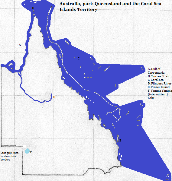
Australia's Great Dividing Range, running north to south, separates Queensland into the arid western plains and the eastern fertile coastal plain. The range begins at the top of the Cape York Peninsula and only moves away from the coast south of 18 degrees, then returns to near it in the state's southeast. They rise to more than 1,600 meters. The plains' dryness is mitigated by a vast artesian basin, which supports well irrigation. Off Queensland's east coast is the world's largest barrier reef, and beyond it more reefs in the Coral Sea Islands Territory. The Great Barrier Raf is a UNESCO World Heritage Site. Other islands include the Wellesley Islands in the Gulf of Carpentaria, the Torres Strait Islands north of Cape York and Fraser Island next to the southeast coast. Fraser constitutes a World Heritage Site and a tourist destination. Tributaries of the Darling drain southwest from the state's southeast. Otherwise long seasonal rivers drain southwest into the deserts of northeast South Australia, or north into the Gulf of Carpentaria, while short rivers drain Cape York Peninsula and the east side of the Great Dividing Range.
Other World Heritage Sites are: the Riversleigh unit of Australian Fossil Mammal Sites; many units of Gondwana Rainforests;
More than four million people live here, most of them in the state's southeast. Most people speak English; no other language accounts for as many as one in twenty speakers, and most of the minorities are urban immigrants. I do not know the breakout of religion by state, but the pattern in each presumably approximates the national one. National relgious statistics vary wildly, but is is safe to say that more than 19 in 20 are culturally Christian, that most of those remain observant, and that observance is represented chiefly by Anglican Protestants and Roman Catholics, with other Christians together consituting less than either of these groups.
Brisbane is the area's largest city. Other cities of note include Gladstone, Gold Coast, Cairns and Townsville.
Two ports worthy of mention are Weipa (bauxite) and Hay Point (coal).
There is significant amounts of natural gas west north west of Rockhampton, some of it associated with coal deposits.
Before the 19th century people here spoke only Trans New Guinea languages--spoken on a couple of islets in the Torres Straits--and Australian languages--everywhere else. The aboriginal Australians followed similar spiritualist religions and both groups may have been here 20,000 years or more.
Contacts from the north had very little impact, but the arrival of the British overwhelmed local cultures, due to genocide, intentional cultural destruction, persistent slavery, aggressive Christian proselytyzing, and the pragmatic advangages of assimilation. Other Europeans were invited to join the English speakers and assimilate, and very recently Asians have been allowed to join them.
at or near Daintree National Park, Queensland, Australia
north of Cape York
northeast and east
south
west
northwest of the northwest
northwest of Cape York