| To Duval Family Home Page | Oceania |
| To Chris Home Page | Australia |
| To Earth (Geography Home Page) | Australia and its possessions |
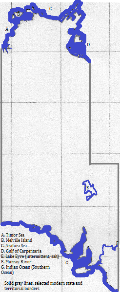
Most of the Northern Territory and half of South Australia sit atop Australia's Western Plateau; to its east are the Central Lowlands, interrupted in the south by the Flinders and Barrier Ranges. Much of the west and center is arid, but the Barkly Tableland in the northeast is grassy and the Murray River valley in the southeast is irrigated farmland. There are three large islands in the north: the barely separated Bathurst and Melville island west of the Coburg Peninsula and Groote Eylandt in the Gulf of Carpentaria. Kakadu National Park in the northwest is a UNESCO World Heritage Site and is popular with tourists.
West of the Gulf of Carpentaria is Arnhem Land, part of the plateau. In the southwest of the Northern Territory the highlands reach their highest points--about 1,500 meters--in the MacDonnell Ranges, with the Musgrave Ranges in northwest South Australia nearly as high. UNESCO honors as a World Heritage Site the mountains of Uluru (Ayres Rock) and Kata Tjuta (the Olgas), which are popular with tourists.
The Spencer Gulf, the York Peninsula, Kangaroo Island (a popular tourist destination), the Flinders Range, St. Vincent Gulf and the Mount Lofty and Barrier Ranges together mark a set of parallel north-south exceptions to the general topography. North and west of these features are Australia's largest saline mud flats: Lake Eyre (North and South), Lake Torrens and Lake Gardner.
Besides the Murray, this area includes several permanently flowing rivers in the north; the longest is the Roper.
Less than two million people live here, most of them in southeast South Australia. Most people speak English; no other language accounts for as many as one in twenty speakers, and most of the minorities are urban immigrants. I do not know the breakout of religion by state, but the pattern in each presumably approximates the national one. National relgious statistics vary wildly, but is is safe to say that more than 19 in 20 are culturally Christian, that most of those remain observant, and that observance is represented chiefly by Anglican Protestants and Roman Catholics, with other Christians together consituting less than either of these groups.
Adelaide is the only metropolis with more than a million residents.
Important ports besides that of Adelaide are Port Pirie, which exports product from the world's largest lead smelter, Before the 17th century only Australian languages were spoken here. The Sultanate of Makassar introduced a few words to some local languages but otherwise things remained the same until the 19th century. The aboriginal Australians followed similar spiritualist religions and may have been there for 20,000 years or more. Contacts from the north had very little impact, but the arrival of the British overwhelmed local cultures, due to genocide, intentional cultural destruction, persistent slavery, aggressive Christian proselytyzing, and the pragmatic advangages of assimilation. Other Europeans were invited to join the English speakers and assimilate, and very recently Asians have been allowed to join them. north of Arnhem Land 1. The first, second and third largest 'lakes' in Australia.Who was there before?
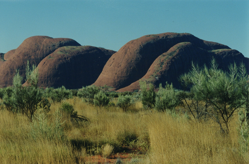
Kata Tjuta (the Olgas), Northern Territory, AustraliaAround the Area
east of Arnhem Land
east of central and southern Northern Territory and of northeastern South Australia
east of center-east South Australia
east of southeast South Australia
south
west
northwest
Footnotes
2. Many of the remaining Protestants have joined in a Uniting Church.
3. http://en.wikipedia.org/wiki/Port_Pirie (accessed 9/23/2014) says the port has the world's largest smelter. Since 'ore' (see Footnote 4) is the port's significance, I assumed refined lead is the type of 'ore.'
4. The Times Atlas of the Oceans (Van Nostrand Reinhold Company, 1983), "commodity loading ports" map.
5. The Economy section of http://en.wikipedia.org/wiki/Gove_Peninsula (accessed 9/23/2014) mentions the bauxite mines and alumina refinery. Since 'bauxite/ phosphate/ alumina' (see Footnote 4) is the port's significance, I assumed alumina is the particular material being shipped out.