| To Duval Family Home Page | Oceania |
| To Chris Home Page | Australia |
| To Earth (Geography Home Page) | Australia and its possessions |
Most of Western Australia sits on the nation's Western (or Great) Plateau; the chief exceptions are the Great Sandy Desert in the northwest, much of which is lowland, and the Nullarbor Plain in the southeast, continuing into South Australia. Otherwise low altitudes stay near the coast.
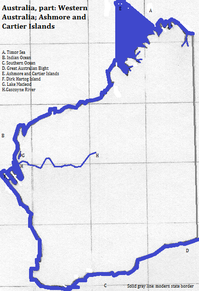
In the north is the Kimberley Plateau and King Leopold Ranges, rising to nearly 1,000 meters, which are bounded southwest by the Great Sandy Desert. Several rivers flow northward into inlets; one is dammed to form Lake Argyle. The south side of the King Leopolds is drained by the Fitzroy system, flowing westward.
Southwest of the Great Sandy Desert, the land rises up to the Hamersleys, which reach over 1,200 meters. The Ashburton, on the south side, is the most important river. Southeast of these mountains is the Gibson Desert.
Southwest of the Hamersleys is Shark Bay, a double inlet partly defined by islands. Near its north shore is Lake Macleod, a permanent salt lake. Just south of it is the mouth of the Gascoyne River.
In the southeast, north of the Nullarbor Plain is the Great Victoria Desert, stretching into South Australia. Much of the remainder of the land, save the very southwest, is arid, speckled with saline mud flats like Lake Carnegie.
UNESCO honors three natural areas as World Heritage Sites: Ningaloo Reef, off Northwest Cape; Purnululu National Park, in the Bungo Bungo Mountains and the Ord River valley; and Shark Bay. All three are tourist attractions. Other tourist attractions are the Margaret River; Broome and the Kimberley; Rottnest Island (off shore from Perth); Karijini National Park in the Hamersley Ranges; Esperance Bay and Capele Grand National Park; and the Pinnacles in Namberg National Park.
Just over two million people live here, most of them in the southwest. Most people speak English; no other language accounts for as many as one in twenty speakers, and most of the minorities are urban immigrants.
I do not know the breakout of religion by state, but the pattern in each presumably approximates the national one. Relgious statistics vary wildly, but is is safe to say that more than 19 in 20 are culturally Christian, that most of those remain observant, and that observance is represented chiefly by Anglican Protestants and Roman Catholics, with other Christians together consituting less than either of these groups.
Metropolitan Perth has more than a million residents. This state capital is at the mouth of the Swan River in the southwest. Within its metropolitan area are Belmont, Swan and Freemantle. Other cities of note are: Karratha, Geraldton, Bunbury and Albany. Outside of these cities, there are important ore ports
Prior to the 19th century everyone spoke Australian languages, and followed similar spiritualist religions. These groups may have been there 20,000 years or more.
Contacts from the north had very little impact, but the arrival of the British overwhelmed local cultures, due to genocide, intentional cultural destruction, persistent slavery, aggressive Christian proselytyzing, and the pragmatic advangages of assimilation. Other Europeans were invited to join the English speakers and assimilate, and very recently Asians have been allowed to join them.
north
east
south, west and northwest
1. The source for tourist attractions is the first ten from http://www.planetware.com/tourist-attractions-/western-australia-aus-wa-wa.htm, accessed January 30, 2017. The listing for Shark Bay mentions Monkey Mia, which is in the bay's area.
2. Many of the remaining Protestants have joined in a Uniting Church.
3. The Times Atlas of the Oceans (Van Nostrand Reinhold Company, 1983), "commodity loading ports" map.