| To Duval Family Home Page | South America |
| To Chris Home Page | Brasil |
| To Earth (Geography Home Page) |
This area is mostly within the Amazon Basin, but the northern half of Roraima and the border of Brasil's Amazonas State with Venezuela's Amazonas Territory are in the Guiana Highlands, which reach over 3000 meters. The northwestern slopes receive much rainfall; the southern ones, less.
The Amazon lowlands, covered with tropical forests (selva), are a mixture of riverine flood plains (varzeas), and slightly higher ground (terra firme). Most of the terra firme soils are subject to catastrophic rates of erosion if the land is deforested.
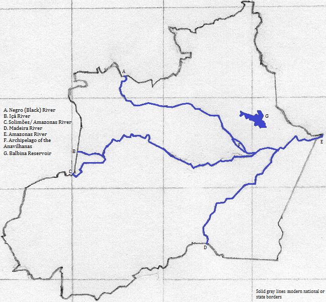
The Amazonas River
On the right (south) bank are the Javari,
There is one UNESCO World Heritage Site in the area: the Central Amazon Conservation Complex.
Tourists enjoy the Amazonas River.
The city's chief city is Manaus.
So little was recorded at early Luzo-Brazilian contact, and so much change has been wrought since, that the best way to reconstruct the pre-Columbian past is to generalize from the present day distribution of indiginous languages, but this is admittedly error prone.
Major language groups
Some of the Tupi languages found in this area are possibly derived from a form of Tupi that became the lingua franca in the colonial era and continued in that role even as late as the early 20th century.
Portuguese speakers began arriving in the 17th century, perhaps earlier, and indiginous populations dwindled from disease, slavery and exploitation in the rubber industry. Most indiginous people adopted Roman Catholic Christianity, and many switched their family language to Portuguese.
northeast of Roraima
east
southeast of Amazon State
south of Acre State
southwest of Acre and west of Amazon State, south of the river
west of Amazon State, north of the river
north
1. Officially Brasil since the late 19th century. English uses the older name: Brazil.
2. Norte in Portugese.
3. Amazon in English.
4. The Amazonas is the worlds' second longest, South America's longest. Within Brasil its upper portion is called the Solimões.
5. Known as the Putumayo outside of Brazil.
6. South America's sixth or seventh longest.
7. Translates as Black from Portuguese or Spanish. South America's tenth longest.
8. Known as the Vaupés outside of Brazil.
9. Yavarí in Spanish.
10. South America's third or fourth longest.
11. South America's third or fourth longest.
12. www.touropia.com/tourist-attractions-in-brazil, accessed 4/7/2014.
13. Joseph Greenberg would clasify all pre-Columbian Brazilian language groups together as Amerindian.
14. Also spelled Tukanoan.
15. Also called Yanomami.
16. Carib and Panoan are sometimes considered part of a Ge-Pano-Carib group.