| To Duval Family Home Page | Africa |
| To Chris Home Page | Angola |
| To Earth (Geography Home Page) | United Kingdom and its possessions |
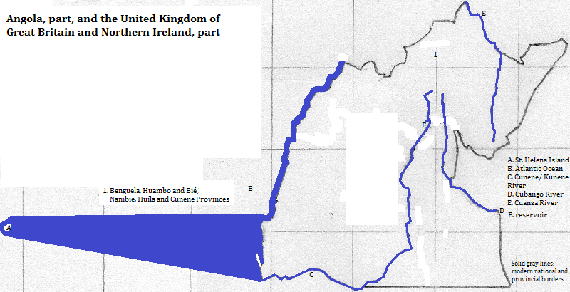
This part of Angola, comprising more than 350 thousand square kilometers, is all plateau beyond a narrow coastal plain. The high land peaks at over 2,500 meters in the Bie Plateau, but much of it is below 1,500 meters.
The rivers reaching the area's Atlantic coast are, with one exception, short. The Cunene,
Two other river systems are important. The Cubango
The biggest lakes are reservoirs along the Cunene River.
This area also includes St. Helena, a volcanic British island west of this area and east of the mid-Atlantic oceanic ridge.
Caotinha Beach, 26 kilometers from downtown Benguela, is liked by tourists due to its small size and the view of Mount Caota above it.

Over five million people live here (2007). About three in four speak Umbundu;
Probably a majority are Christian; perhaps a majority are Roman Catholic Christians. Most Christians retain beliefs in older ways: ancestral spirits and divination. Among non-Christians, the world religion has had its influence by elevating a chief god's relative position. But these indiginous religions are more focused on ancestral and natural spirits, on the manipulation of worldly events and conditions by practioners of magical (heriditary or learned) and on diviners, often called kimbandas. The Ovambo, which include Kwanyama speakers, have a set of clans with an associated meat or fruit that is taboo as food.
A more recent development is the Our Lord Jesus Christ Church in the World, founded in 1949 by Simon Mtoko (Simão Toco). The Mtokoists of Benguela Provine were implicated in riots, and the religion was banned for a time.
Huambo is the largest city. Tourism is important in two cities: Lubango and Namibe.
It is speculated that a thousand years ago two groups, together called Khoisan for convenience, occupied the area. One is the linguistic family called Khwe or Khoe or Hottentot or Central Khoisan, and the other the !Kung or Ju or Northern Bushman or Northern San family. There are a few thousand speakers of !Kung languages like Kung-Ekoka, Maligo and !O!ung, but the local Khwe langauge, Kwade, was last spoken during the previous century. Bantu speakers became predominant in the last millenium, probably in at least two migrations. Umbundu moved to the fore first as trading partners with the Lunda and then as slave raiders and goods traders for the Portuguese; their centralized political structures assisted them until these were eliminated in the early 20th century. The abolition of kings among the Umbundu, Ovambo and Nyaneca removed the chief priests. Into the gap went Christian missionaries and their institutions.
north
northeast
east
southeast and south
west
1. Spelled Kunene in Namibia.
2. Spelled Kavango in Namibia. Called the Okavango in Botswana. It does not reach the sea, although some of it occasionally spills into the Zambezi system.
3. Also called South Mbundu or Benguela Mbundu. The people are called the oviMbundu.
4. Also spelled Kwanhama. They are part of the group called Ovambo or Ambo.
5. Also called Nyaneka-Humbe. Humbe is a dialect. Nyaneka is also spelled Haneca or Nhaneca and Humbe spelled Nkumbi.