| To Duval Family Home Page | Africa |
| To Chris Home Page | Angola |
| To Earth (Geography Home Page) |
Namibia's 835 thousand square kilometers are dividable into four parts; three are: the Namib Desert, a coastal dry plain; a central plateau with massifs; and an eastern high desert--lower in the southeast, the Kalahari. In the very northeast is a swampy protruberance: the Caprivi Strip.
Cuando-Cubango
In the north, Namibia's tallest point, Brandberg, is well west of the main central spines of massifs; it reaches above 2,500 meters. The northern part of the central heights is nearly as high. Further south the highlands split on both sides of the Vis
Tourist destinations for nature lovers in Namibia include: Etosha National Park in Kunene Province; the Vis (Fish) River Canyon in Karas Province; Sossusvlei in Hardap Province; Cape Kruis (Cross) on the Erongo provincial coast; Spitzkoppe between Swakopmund and Usakos in Erongo Province; the natural areas of the Caprivi Strip; and the Skeleton Coast on the Kunene provincial coast.
Over 2.2 milion people live here (2007) and nearly three in four speak languages in the Ndonga Group, chiefly Ndonga, by over seven in 20, and Kwanyama, by somewhat fewer. Important languages outside the group are Nama, spoken by almost one in ten; Afrikaans, by more than one in 20 at birth (and learned by others); Nyemba, by nearly one in ten; and Herero, by just over one in 20.
Most
The capital of Namibia is Windhoek.
Most of Namibia's residents of long ago spoke languages in the Central Southern Africa Khoisan languages, like today's Nama and Kxoe. In northern Namibia and Cuando-Cubango, they also spoke Northern Southern Africa Khoisan tongues; there are still some speakers of current representatives of the group, like Ju|'hoan, Maligo, !O!ung and Kunk-Ekoke.
The petroglyphs of Twyfeltontein,
Later--in the last millenium, Bantu speakers arrived. The Ndonga Group, Nyemba and Herero are among their current representatives.
Last came Europeans. Missionaries brought Christianity to the coast in the late 18th century, followed by colonial rulers. Quarrels among the Europeans led to the occupation of Namibia by South Africa, and thus to the introduction of the Afrikaans language.
Tourists like to visit Swakopmund (Erongo Province), a current town and resort exhibiting German colonial architecture, and the former German diamond-mining town of Kolmanscop, located near Lüderitz in Karas Province.
west and northwest of Cuando-Cubango, and north of northwestern Namibia
northeast of Cuando-Cubango
east of Cuando-Cubango, and north of the eastern Caprivi Strip
south of the Caprivi Strip, and east of Namibia's north and center
east and south of southern Namibia
west of Namibia
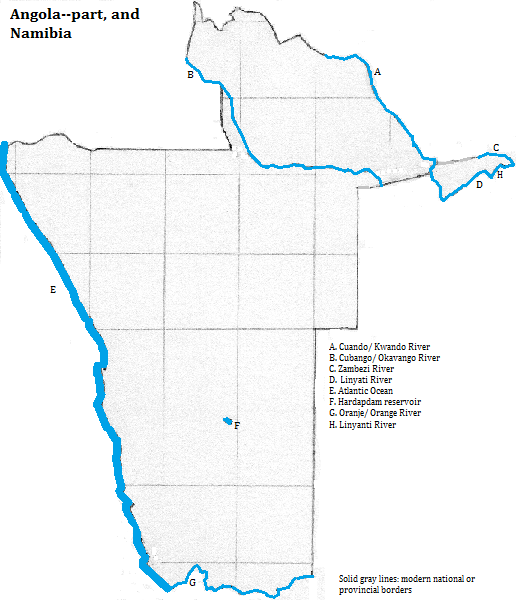
1. Strip in Afrikaaner is Zipfel.
2. Also spelled Kwando-Kubango.
3. Also called the Cubango or the Okavango. While it occasionally spills over into the Zambezi system, it is generally considered a separate system that empties into a swamp. It is Africa's ninth or tenth longest river.
4. Also called the Kuando or Kwando.
5. Spelled Zambeze in Angola. It is Africa's fourth longest river.
6. Or Fish.
7. Or Orange. It is Africa's sixth longest river.
8. More than nine in ten Namibians are Christian according to the International Religious Freedom Report 2003, published by the U.S. Bureau of Democracy, Human Rights and Labor, www.state.gov/g/drl/rls/irf/2003/23743.html, accessed 10/8/2007.
9. Ibid.
10. Also called /Ui-//aes.