UNESCO honors the Virgin Komi Forests
The Timan Pechora Oil Basin lies between the Urals and the Timan Ridge and includes the Nizhne-Chutinskoye Field that staddles northern Komi and the Nenets Autonomous Okrug of Arkhangel'sk Oblast. The Vaktyl Gas Field is located along the right bank of the Pechora near its confluence with the Vaktyl (Komi Republic).
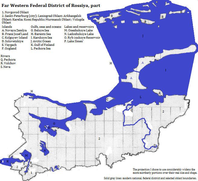
Map
Who lives there?
About six in every seven people speak Russian as their first language, and most of the rest learn it. No other first language accounts for as many as one in twenty.
More than nineteen in every twenty are culturally Russian Orthodox Christian, though the degree of observance, or even belief, varies, a relic of communism's coercive bias toward aetheism.
Санкт-Петербург (Sankt-Peterburg)
UNESCO honors five places as cultural World Heritage Sites:
Additionally UNESCO's site for the Struve Geodetic Arc includes two places on Gogland Island (Leningrad Oblast).
Who was there before?
Speakers of a subdivision of Uralic languages, Finno-Permian languages, moved into the area from the south between the third and first millenia B.C.E. Early in that period the Permian branch became distinct, eventually giving rise in this area to Komi, still a minority language in the Komi Republic. Proto-Finnic, another branch, split off in the first millenia B.C.E. Over the centuries the dialects diverged somewhat, but national boundaries are the chief reason for regarding the Karelian dialects or languages as distinct from Finnish or even Estonian.
Eastern Slavs arrived from the south in the second half of the first millenium, settling by Lake Il'men' and its northern river outlet. Further expansion--to the Baltic and the Urals--took place in the centuries around the turn of the millenium, but the colonists probably long remained but an elite minority beyond the vicinty of the lake and river. It was only in the last few centuries that they became the majority throughout the area. The early religion of the people who spoke Komi and Karelian was most likely similar to other Uralic religions. These include a sky god, often inactive, a dualistic creation myth and shamanism. Christian missionaries used violence against people and idols to suppress these religions.
The pre-Christian East Slavs worshipped many gods including thunder gods, a god of livestock, a solar god and a fertility goddess. Chistianity converted the Slavs, oftern violently, during the 11th and 12th centuries. This area remained Orthodox when Novgorod Principality was absorbed by the Москва (Moskva)
Around the Area
Around Franz Josef Land:
north and east
south
Around the rest:
northeast of Novaya Zemlya
east of Novaya Zemlya and north of the Yugorskiy Peninsula
east of the Nenets Autonomous Okrug and of the Komi Republic's south, and southeast of the Komi Republic
south and southwest of the Komi Republic, south of southeastern Archangel'sk Oblast, and east of Vologda Oblast
south of Vologda Oblast, and southeast of Novgorod Oblast
southwest of Novgorod and Leningrad Oblast
west of Leningrad Oblast
northwest of Leningrad Oblast, and west of Karelia and of Murmansk Oblast
northwest of Murmansk Oblast
north of the mainland
Footnotes
1. Grad means town. The oblast excludes the renamed city of Sankt-Peterburg.
2. Also transliterated from Russian as Archangel'sk. It includes the Nenets (Neneckij or Nenetskiy) Autonomous Okrug.
3. Karelija is a stricter transliteration. Also called the Karel'skaya (Karel'skaja) Republic.
4. Rossija in an alternate transliteration. Russia in English.
5. Vostochno-Evropeyskaya Ravnina in transliterated Russian. Also called the Russian (Russkaya) Plain.
6. Kil'skiy (or Kolskij) Poluostrov in transliterated Russian.
7. Beloje (or Beloye) More in transliterated Russian.
8. An alternate transliteration is Ladožskoje Ozero or, in English, Ladoga. It is Europe's largest lake.
9. An alternate transliteration is Onežskoje Ozero, or in English, Onega. It is Europe's second largest lake.
10. Valdayskaya (or Valdajskaja) Vozvyshennost' (or Vazvyšennost') in transliterated Russian.
11. Timanskiy Kryazh (or Timanskij Kryaž) in transliterated Russian.
12. Or Pečora. It is Europe's sixth longest river.
13. North is svernaja or svernaya in translierated Russian. The river is Europe's tenth longest.
14. Europe's longest river.
15. Rybinskoje vodochranilišče (or vodokhranilishche) in transliterated Russian. It is perhaps Europe's fourth largest lake.
16. Severnyy or Severnjy in transliterated Russian.
17. Or Novaja Zeml'a. The northern island is Europe's fourth largest; the southern is sixth.
18. Barencevo (or Barentsevo) More in transliterated Russian.
19. Karskoje or Karskoye More in transliterated Russian.
20. Zemlya Frantsa-Iosifa in transliterated Russian.
21. There are two units: the Pechora-Ilych Natural Reserve and Yugydva National Park.
22. Saint Petersburg in English. Formerly Petrograd, that is Petertown, and Leningrad, that is, Lenintown.
23. Could be translated as new town.
24. http://www.touropia.com/tourist-attractions-in-russia/, acc. Dec. 6, 2016. The Hermitage Museum comprises six buildings including the Winter Palace.
25. Moscow in English.