| To Duval Family Home Page | Asia |
| To Chris Home Page | भारत (Bhārat or India) |
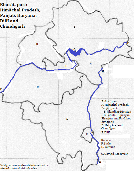
| To Earth (Geography Home Page) | North India's core |
These 151 thousand square kilometers are in northern India. There are three geophysical zones: the Himalaya Mountains of this area's northeast, the Indo-Gangetic plain and a piece of the Thar, or Great Indian, Desert near the Haryana-Punjab border in the area's southwest.
The mountains consist of three parallel ranges: the Zaskar in the extreme northeast, along Himachal Pradesh's border; the Great Himalayas, and the Lesser Himalayas, here also called the Siwalik Range. The latter reach above 4,000 meters in the Dhaola Hills. The Great Himalayas locally reach above 6,500 meters.
Two ocean-reaching river systems, the Indus and the Ganga,
The Ganga system is represented here by the Yamuna.
The Indus system is represented here by four of the "five waters" of Indo-Pakistani Panjāb:
The Great Himalayan National Park in हिमाचल परदॆश (Himāchal Pradesh) is a UNESCO World Heritage Site honoring nature.
More than 70 million people live here (2007). More than 19 in 20 speak Hindi, Urdu or Eastern Panjabi, mutually intelligible languages that are written in three scripts and associated with three religions.
There are five cities with more than a million residents: डिलली (Dillī) and its suburbs, फरीदाबाद (Pharīdābād or Farīdābād) in the area and गाजियाबाद (Gājiyābād or Ghāziābād) in nearby Uttar Pradesh (Northern State), Ludhiana, डिलली (Chanḍīgarh) and Amritsar.
There is one UNESCO World Heritage Site honoring modern culture: the Kalka-Shimla Railway.
The Harappan civilzation was in Panjāb about four thousand years ago. The Harappan language and religion is unknown.
Indo-Aryans moved into this and other parts of India, probably in the second millenium BCE. Their language of Sanskrit may have been in use as far back as 1000 BCE. or earlier, and had become a liturgical and literary language by 500 BCE.
The Indo-Aryans brought their religion with them, but it had already begun to move away from common Indo-European roots. The elite form of the religion, featuring Varuna, Indra and Soma, was written down in the first millenium BCE. Over time this Vedic religion embraced more elements, and transformed into Hinduism. During the changes rival religions arose: Buddhism, Jainism and Ajivikaism being the three most important.
By the beginning of the first millenium CE, the Ajivika religion was gone and the area had a mixture of Hinduism, Buddhism and Jainism. The conquering Iranian groups in the early first millenium CE, the Sakas and Kushanas, did not change this mix, which persisted into the second millenium.
After the second millenium, Jainism and Buddhism faded away. Islam arrived before the area was conquered by the Islamic Moghuls, and gained in importance under their rule. Many Moslems left when Pakistan was created.
Hindi dialects, including Eastern Panjabi, developed in the first half of the last millenium.
The Sikh religion started in Panjāb in the 15th century.
ਜਲੰਧਰ (Jalandhar)
| Name | Year | Population | Political entity |
| Jalandhar | 100 CE | Basileia Kossanõn (Kushan Empire) | |
| Sthanishvara | 622 | Pushyabhuti state | |
| Sthanishvara | 1000 | Pratihara Empire | |
| Jalandhar | 1800 | Sarkar-i-Khalsa (Sikh Empire) | |
| Jullundur | 1900 | 77,000 | Empire of India (part of the United Kingdom of Great Britain and Ireland) |
| ਜਲੰਧਰ (Jalandhar) | 2011 | 862,000 | भारत (Bhārat or India) |
| थानेसर (Thānesar) | 2011 | 155,000 | भारत (Bhārat or India) |
There are three UNESCO World Heritage Sites honoring pre-modern culture, all in डिलली (Dillī): Hamayun's Tomb; the Qutb Minar and its monuments; and the Red Fort Complex.
north
east
southeast of Himachal Pradesh and east of Haryana
southwest
northwest
1. India in English.
2. Punjab in conventional English transliteration.
3. Proper rendering of the 'PR' in Pradesh in the Devanāgarī script is a conjunct with a downward left stroke attached to the bottom left of प.
4. The च is an unaspirated 'ch.' Some transliterations map this to just 'c.' Pradesh means state.
5. Haryana or Haryāna in conventional English transliteration. The last two vowels are both represented by ा, but I followed convention in only putting a macron on the middle one.
6. The च is an unaspirated 'ch.' Some transliterations map this to just 'c.'
7. Proper rendering creates a composite letter out of the two ल letters, with a single vertical line on the right.
8. Delhi in English.
9. I do not know the name of the tallest peak. De Tibba is mentioned in Hugh Swift, The Trekkers's Guide to the Himalaya and Karakoram but it's height is given at 19,600 feet, just over 6,000 meters, whereas atlases show a peak of 6,632 or 6,517 meters, depending on the atlas.
10. I do not know its name; it is northeast of the village of Kibar.
11. Ganges in English.
12. Also called the Jumna.
13. Panjāb (Punjab in English) means 'five waters.'
14. The ਪੰਜਾਬ/ (Panjāb)/ Jammu and Kashmir border is uncertain.
15. Chung-hua is an alternate transliteration. China in English.
16. Most people treat Eastern Panjabi or Panjabi as a separate language from Hindi; Eastern Panjabi is often lumped with the quite different Western Panjabi (Lahnda) and less often with Siraiki. The religious affiliation is so pronounced that some Eastern Panjabi-speaking Hindus say they speak Hindi when all their Sikh neighbors say they speak Panjabi. Urdu is also treated as a separate language from Hindi, though less frequently than Eastern Panjabi.
17. Formerly called Jullundur in English.
18. 2011 figure from https://en.wikipedia.org/wiki/List_of_cities_in_India_by_population, accessed February 26, 2017.
19. Formerly (in transliteration) Sthanishvara.
20. 2011 figure from the side bar of https://en.wikipedia.org/wiki/Thanesar, accessed February 26, 2017, which cites http://censusindia.gov.in/2011-prov-results/paper2/data_files/India2/Table_2_PR_Cities_1Lakh_and_Above.pdf, which I accessed March 13, 2018. The city is not listed in 2011 figure from https://en.wikipedia.org/wiki/List_of_million-plus_urban_agglomerations_in_India, accessed February 26, 2017, presumably because it did not meet the definition of 'urban agglomeration,' even though its size exceeded the cutoff.
21. I do not know how the city's name was written in 100 CE or even if this, or some close variant, was the name then used.
22. Tertius Chandler, Four Thousand Years of Urban Growth, 2nd ed. (The Edwin Mellen Press, 1987), "Tables of the World's Largest Cities." In 100 CE it was smaller than Tosali, which was smaller than Angora, which had 34 thousand residents. It was larger than 湖州 (Hangzhou), which was larger than Changsha, which was larger than Ayodhya, which was larger than Tunhuang, which had 32 thousand residents. In 100 CE it was then the largest city in this part of what is now भारत (Bhārat or India). He does not indicate how he came by this estimate, nor did I find support for the prominence of the city in Joseph E. Schwartzberg, ed., A Historical Atlas of South Asia (University of Chicago Press, 1978). In 1800 it was smaller than Ichang, which was smaller than Guizhou, which was smaller than Nizampatam, which was smaller than Ellichpur, which was smaller than Jaén, which had 25 thousand residents. It was larger than Bulaq, which had 24 thousand residents.
23. I do not know the proper rendering of the city's older name.
24. Chandler, op. cit. In 622 CE the city was smaller than Coptos, which waas smaller than Samarkand, which had 45 thousand residents. It was bigger than Thessalonica, which had 40 thousand residents. In 1000 it was smaller than Kashbar, which was smaller than Qus, which had 45 thousand residents. It was larger than Balasaghun, which was larger than Hsiangyang, which was larger than Lhasa, which was larger than Ujjani, which was larger than Liaoyang, which had 40 thousand residents. In 622 and 1000 it was the largest city in this part of what is now भारत (Bhārat or India).
25. I do not know the city's name in Persian, which was the court language of the Sikh Empire.