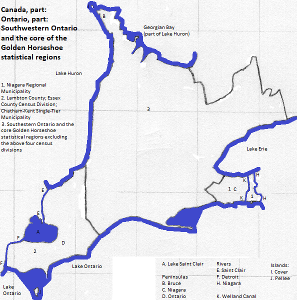
Southwestern Ontario and the core of the Golden Horseshoe statistical regions
How is the land laid out?
This area comprises two statistical regions of the province of Ontario in Canada: Southwestern Ontario
The Canadian Shield extends into the part of this area that is north of the Great Lakes. Its most notable local hydrologic features are the lakes that mark its boundary with the interior plains, which include Lakes Huron, Erie and Ontario. These lakes are connected by waterways: part of the St. Lawrence River system. The peninsula of southern Ontario, defined by the lakes and waterways, lies entirely within the Eastern Lake Section of the Central Lowland of the Interior Plains. Bruce Peninsula National Park and the Fathom Five National Marine Park (just beyond the tip of Bruce Peninsula) are both popular with tourists.
Map

Who lives there?
This area is in the part of North America in which English-speakers and Christians are the majority.
One city has over a million residents: Toronto. Within its metropolitan area are Vaughan and Mississauga. A smaller city is Stratford (population 31 thousand
The metropolitan areas of the non-Canadian cities of Detroit and Buffalo spill over into the southwest and southeast of this area, respectively. The latter includes Niagara Falls, Ontario.
Who was there before?
Iroquoian languages--Huron, Tobacco, "Neutral" and Erie--were spoken on the province's peninsula.
The French were the first Europeans to arrive, settling on the southern peninsula and near the lake shores. Their few numbers were overwhelmed by English-speaking settlers who arrived in great numbers from the south after the United States won independence from Great Britain.
Around the area
northeastbeyond Lake Ontario and east of the Niagara River
southeast from peninsular Ontario
south of Lake Erie
beyond Lake Huron, and west of the Saint Clair and Detroit rivers and Lake Saint Clair
Footnotes
1. Southwestern Ontario comprises: the single tier municipalities of the County of Brant, Chatham-Kent, Haldimand County and Norfolk County; the separated munciaplities of Brantford, Guelph, London, Pelee, Sarnia, St. Marys, St. Thomas, Stratford, Windsor and Woodstock; the regional municipalities of Oxford County and the Waterloo Region; and the counties of Bruce, Dufferin (partially extended), Elgin, Essex, Grey, Huron, Lambton, Middlesex, Perth and Wellington.
2. The core of the Golden Horseshoe comprises: the regional municipalities of Durham, York, Peel, Halton and Niagara; and the single tier municipalities of Toronto and Hamilton.
3. https://www.planetware.com/tourist-attractions-/ontario-cdn-on-on.htm, accessed October 17, 2018.
4. 2016 figure from the side bar of https://en.wikipedia.org/wiki/Stratford,_Ontario, accessed October 17, 2018.