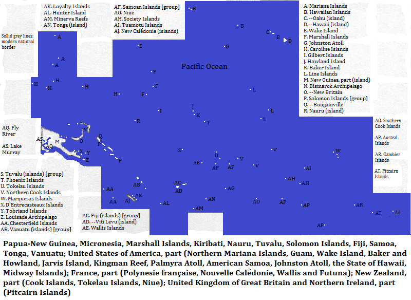
To Duval Family Home Page Oceania
To Chris Home Page France and its possessions
To Earth (Geography Home Page) United States of America
The United Kingdom of Great Britain and Northern IrelandNew Zealand and its possessions

Papua-New Guinea; Micronesia; Northern Mariana Islands (United States of America); Guam (United States of America); Marshall Islands; Kiribati; Nauru; Wake Island (United States of America); Baker and Howland Islands (United States of America); Jarvis Island (United States of America); Kingman Reef (United States of America); Palmyra Atoll (United States of America); Polynesie française1(France); Cook Islands (New Zealand); Tokelau Islands (New Zealand); Tuvalu; Solomon Islands; Pitcairn Islands (United Kingdom of Great Britain and Northern Ireland); Niue (New Zealand); American Samoa (United States of America); New Calédonie2 (France); Johnston Atoll (United States of America); the state of Hawaii (United States of America); Midway Islands (United States of America); Fiji; Wallis and Futuna (France); Samoa; Tonga; Vanuatu

How is the land laid out?

This area consists of all of Oceania3 except Australia, New Zealand, the Chilean possessions and some Japanese islands, and includes Hawaii. There are tens of thousands of islands ranging from half of New Guinea--the world's second largest--to tiny islets that only show themselves at high tide. Westernmost are the northern Palau Islands--those under Micronesian sovereignty (often considered part of the Caroline Islands). Farthest north is Kure Atoll, the northernmost of the Hawaiian Islands. Most of that chain comprises the American state of Hawaii, whose main islands are heavily settled, despite having two of the area's tallest volcanoes, Mauna Loa and Mauna Kea. Eastermost is Ducie Island, part of the British colony of the Pitcairn Islands. Farthest south is Marotiri Island, part of the Australes. In the northwest the area borders Japan, who owns a share of the South Honshu Ridge. In the west, the rest of New Guinea is part of Indonesia. Australia's Coral Sea Islands border the Solomon Islands, Vanuatu and the Chesterfield Islands. But relatively few people live on these small islands compared to those of Papua-New Guinea or Hawaii.

Eastern New Guinea's landforms are in stripes. Most of the north coast--save the far northwest--consists of a set of mountain ranges. They are interrupted by the mouths of the Sepik and Ramu Rivers which are less than 50 kilometers apart. The southeast end of this stripe reaches over 4100 meters at Mt. Bangera in the Saruwage Range on the Huan Peninsula. The two rivers turn, respectively, west and east to flow north from the mountains. These valleys, together with that of the Markham in the southeast, form the second stripe. The lowlands continue along the Solomon Sea shore until Cape Vogel. The third stripe is another set of mountains--the island's spine which continues to the end of the peninsular southeast. Mounts Gilowe, Kubor, Herbert and Victoria are over 4000 meters, and Wilhelm over 4,500 meters. South of the mountains are more lowlands, narrow in the southeast, and vast and swampy in the southwest. There, numerous rivers empty in wide deltas, the Fly being the biggest. This low area comes within a few miles of Australia's Torres Strait Islands.

UNESCO World Heritage Sites for nature
  • Hawaii Volcanoes National Park (Hawaii Island, state of Hawaii, United States of America)--also a tourist attraction
  • East Rennell (Rennell Island, Solomon Islands)
  • "Lagoons of New Caledonia: Reef Diversity and Associated Ecosystems" (Nouvelle Calédonie island, Nouvelle Caédonie Special Colectivity, France)
  • Henderson Island (Pitcairn Islands, United Kingdom of Great Britain and Northern Ireland)
  • Papahūnaumokuākea (Northwestern Hawaiian Islands, United States of America)
  • Phoenix Islands Protected Area (Phoenix Islands, Kiribati)

  • Tourist attractions for nature4 other than the one mentioned above
  • Benbow lava lakes, Marum lava lakes, Ambryn volcano acid rain (Ambryn Island, Malampa Province, Vanuatu)
  • Benua Cave and sinkhole (Bougainville island, Papua-New Guinea)
  • Rainforest of central Savai'i Island (Samoa)
  • Mayong Spring, the source of the Galowe River or Stream (New Britain Island, Papua-New Guinea)
  • Agaiambo Swamp (Oro Province, New Guinea Island, Papua-New Guinea)
  • Kazumura Cave (Hawaii Island, state of Hawaii, United States of America)
  • Map

    map of Oceania, excluding Australia and New Zealand, showing selected islands and, on New Guinea, selected hydrographic features

    Who lives there?

    Less than ten million live here, with almost half of them in Papua-New Guinea. There is no majority language. English leads and is spoken by more than one in six--but by very few in Papua-New Guinea despite its being an official language there. In fact there is no first language shared by as many as one in 20 in that nation, and the number of birth languages is in in the hundreds. Tok Pisin--an English creole--is spoken by almost half of the residents as a second language; its name means pidgin talk.5 Far to the northeast another English Creole, Hawaiian English, is spoken by about 600,000, most of whom also speak standard English.

    This diversity does not vanish when examining the large language groups. Austronesian languages--mostly Oceanic ones--constitute 40% of the region's first language speakers. Trans New Guinea languages constitute 28% and Indo-European languages--mostly English, English Creoles and French--constitute 22%. Most of the rest speak Japanese, Sepik-Ramu languages, East Papuan languages and Torricelli languages.

    The region is overwhelmingly Christian--almost nine in every ten people. Of these the overwhelming majority are Protestant, most imporantly Anglican, with almost all the other Christians, Roman Catholic.

    There are no giant cities but two smaller places are important. Honolulu, centered on the south coast of Oahu, is the capital of the state of Hawaii. In the center of this area is Nadi, Fiji's commercial port at Viti Levu's west side.

    Some important ports have diminished as phosphate deposits are depleted. The most important were at Banaba Island (Kiribati) and Nauru.6

    Who was there before?

    People have lived in New Guinea for at least 40 or 50 thousand years. The languages spoken there now are probably related to those spoken by the original settlers. There are at least eight fundamental language groups, not counting recent introductions.

    Beyond that island, a branch of Eastern Malayo-Polynesian was spoken long ago, and west of this area became the Oceanic group of languages. These moved east in two waves. The Micronesian Group went to the Carolines, Marianas, Marshalls and Gilbert7 Islands. The other wave reached Samoa and Tonga by 3000 years ago, most of French Polynesia by 2000 years ago and Hawaii by more than 1000 years ago. Europeans began exploring the Pacific in the last 500 years. They introduced settlers to Hawaii and their political dissidents were exiled to New Caledonia, starting in the 19th century. At the same time, they Christianized these islands and eastern New Guinea.

    There is one UNESCO World Heritage Site honoring early culture: the Kuk Early Agricultural Site (New Guinea Island, Papua-New Guinea).

    Tourist attractions for culture4
  • Marae Taputapuatea (Raiatea Island, Leeward Islands, Polynesie française, France)
  • Ha'amonga'a Maui (Trilithon) (Tongatapu Island, Tonga)
  • Awim Cave Art (East Sepik Province, New Guinea Island, Papua-New Guinea)
  • fresh lava, black and red swirls
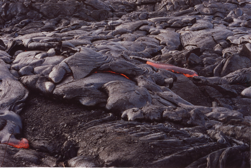
    Fresh lava, Hawaii Volcanoes National Park, Hawaii (island), state of Hawaii, United States of America

    Around the Area

    north, east and south; also between the islands
    west of New Caledonia and Vanuatu, southwest of the Solomon Islands and south of southeastern New Guinea island
    south of southwestern Papua-New Guinea
    west of eastern New Guinea island
    west of the Bismarck Archipelago, and of Micronesia (excluding the northern Palau Islands)
    west of the northern Palau Islands, of the Northern Mariana Islands, and of Guam

    Footnotes

    1. French Polynesia in English.
    2. Caledonia in English.
    3. The nation of Palau is sometimes considered in Oceania, sometimes in Asia; I've used the latter convention and have excluded it from this collection.
    4. http://www.wondermondo.com/Au.htm, accessed April 13, 2016.
    5. The third official language, a pidgin, has few speakers but its use is concentrated in and near the capital.
    6. The Times Atlas of the Oceans (Van Nostrand Reinhold Company, 1983), "commodity loading ports" map.
    7. Or Kiribati in the archipelagic sense.