| To Duval Family Home Page | Asia |
| To Chris Home Page | भारत (Bhārat or India) |
| To Earth (Geography Home Page) |
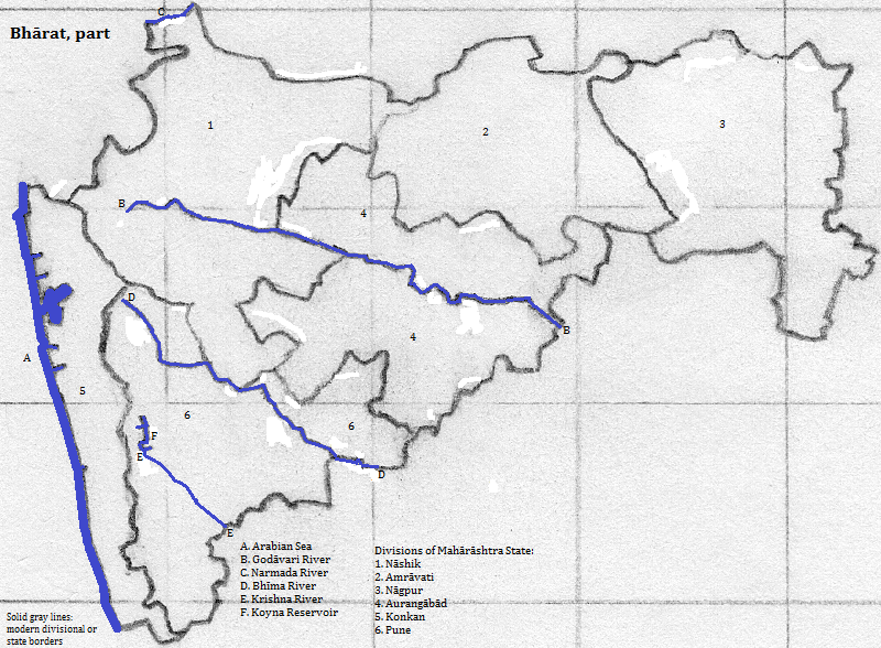
Mahārāshtra includes 308 thousand square kilometers of the northwest of peninsular भारत ((Bhārat).
The chief exception to the pattern is the Tāpti (or Tāpi) River valley, which cuts deep into the plateau, although its western end is in Gujarāt. A similar feature, only a small piece of which is in Mahārāshtra, is the Narmada valley, which follows part of the state's northern border. Between the two is the Sātpura range, most of which is in Madhya Pradesh. Just barely in Mahārāshtra is another high spot in the plateau: the Gawīlgarh Hills, between the upper Tāpti and its main tributary. South of the entire Tāpti system is the Sahyadriparvat or Ajanta range.
Flowing out of there and heading east is a tributary of the Godāvari: the Penganga (or Painganga). Further south is the Godāvari proper. Separating its headwaters from the Bhīma's is the Harischandra Range. Another watershed boundary is the Mahādeo Range, which keeps the upper Krishna system apart from its tributary, the Bhīma. The last of these heights is the Bālāghāt Range, which keeps the Mānjira river away from its eventual destination, the Godāvari.
The largest bodies of inland water are reservoirs like the Koyna.
UNESCO honors four spots in the Sahyadri part of the Western Ghats as part of a World Heritage Site: the Kaas Plateau; two parts of the Sahyadri Tiger Preserve (the Koyna Wildlife Sanctuary and Chandali National Park); and the Radhanagari Wildlife Sanctuary. Tourists also enjoy Tadoba National Park and Tiger Reserve.
Mahārāshtra's population was 103 million in 2005.
Hindus are the overwhelming majority, more than eight in ten. Moslems are less than one in ten. Neo-Buddhism, a local branch of the world religion, accounts for more than one in 20.
There are at least five metropolitan areas with over a million residents. मुंबई (Mumbai) proper is huge, and its area includes three other cities with populations over a million and two urban areas with over a million each that are sometimes treated as separate metropolitan areas. The Pune metropolitan area includes one other city with over a million residents. See the list in Maharashtran cities.
UNESCO honors the Chhatrapati Shavaji (Victoria) Terminus in मुंबई (Mumbai) with World Heritage Site status.
Tourists enjoy the beach resort of Ganapatipule; the resort and cultural site of Mahabaleshwar; the setting of the Khandala and Panchgani hill stations; and the urban sites of मुंबई (Mumbai), Aurangabad, Pune and Shirdi.
The area was inhabited by Dravidian-speaking people prior to the arrival of Indo-Aryans.
The Indo-Aryans brought their religion with them, but it had already begun to move away from common Indo-European roots. The elite form of the religion, featuring Varuna, Indra and Soma, was written down in the first millenium B.C.E. Over time this Vedic religion embraced more elements, and transformed into Hinduism. During the changes rival religions arose: Buddhism and Jainism being the two most important. This mix persisted into the second millenium, with Buddhism along the Konkoni coast and Jainism beyond the Ghats. The Virasaivist branch of Hinduism spread its influence from Karnataka, and Jainism declined as it gained. Buddhism also vanished, only to come back among some Dalets in the mid-20th century. Islam arrived before the Moghuls, but became much more important under their rule.
UNESCO honors several older cultural spots with World Heritage Site status: the Ajanta, Ellora and Elephanta caves, all of which are tourist sites.
north
east
southeast
south
west
northwest
1. Ideally the final syllable is rendered by a single ligature for the three akṣaras.
2. India is another official name.
3. Formerly Bombay.
4. http://www.mapsofindia.com/maps/maharashtra/tourism/ and http://goindia.about.com/od/maharastra/tp/top-maharastra-travel-destinations.htm, both accessed 9/29/2014.
5. www.world-gazetteer.com, accessed June 25, 2005.
6. www.censusindia.net/cendat/datatable26.html, accessed May 8, 2007.
7. Joseph E. Schwartzberg, ed., A Historical Atlas of South Asia (University of Chicago Press, 1978), page 165.
8. Article on Marathi in Andrew Dalby, A Dictionary of Languages (Columbia University Press, 1998).