| To Duval Family Home Page | South America |
| To Chris Home Page | Brasil |
| To Earth (Geography Home Page) |
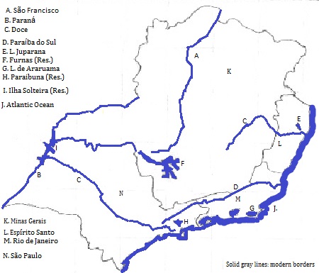
Most of the Southeast
Two great river systems drain the western majority of the region, and shorter rivers in the east flow coastward.
The Paraná
The São Francisco
The Doce and the Paraíbo do Sul
This area shares Portuguese and Roman Catholic Christianity with the rest of Brazil.
There are six metropolitan areas with over a million people: see Southeastern Brasil Cities.
All Pre-Columbian groups would be considered Amerindian by Joseph Greenberg. That said, the languages-extant or known, but extinct, represent the Tupi-Guarani and Macro-Ge groups plus an unclassified language.
Tupinamba, spoken near today's city of Rio de Janeiro, was the source of the simplified language, Tupi, that became a colonial lingua franca for the entire coast northward to the Amazon's mouth, particularly for children of mixed marriages.
Portuguese speakers began arriving in the 16th century and indiginous populations dwindled from disease and slavery. Large numbers of slaves were brought from Africa. Most indiginous and Afro-Brazilian people adopted Roman Catholic Christianity, and many indiginous and all Afro-Brazilian people switched their family language to Portuguese. The Afro-Brazilian version of Catholicism includes elements of the Vodun Religion of west Africa but its adherants regard themselves as pure Catholics.
north
east and southeast
southwest
northwest
1. Officially Brasil since the late 19th century, it is still called Brazil in English.
2. Sudeste in Portuguese.
3. Consists of the states of Espírito Santo, Rio de Janerio, Minas Gerais and São Paulo.
4. Translates from the Portuguese as 'Holy Spirit.'
5. Sierra (da or do or dos) translates from Portuguese as 'mountains of (the)'
6. Translates from Portuguese as 'sea.'
7. Translates from Portuguese as 'Backbone.'
8. Translates from the Portuguese as Saint Paul.
9. Sul in Portuguese.
10. South America's second longest river, the world's ninth.
11. Translates as 'Big' from Portuguese.
12. One of South America's largest lakes.
13. South America's fifth longest river.
14. Do Sul translates as southern from Portuguese.