Belo Horizonte
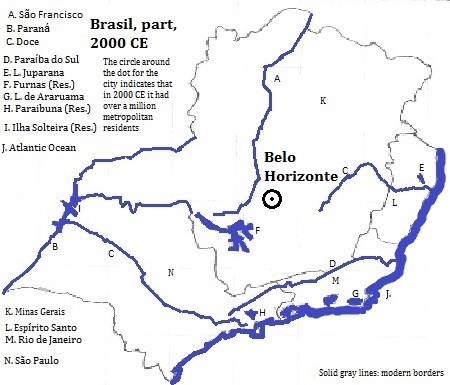
Belo Horizonte,1 the capital of Minas Gerais2 State, Brasil (Brazil) is built located 800 meters up, on the backside of the Sierra do Espinahaco, near headwaters of the Sao Francisco. It serves as a regional center for agriculture, mining and industry, and from the 1890s was a planned city with wide avenues and parks. There are 2.403 million people in the city proper and 6.127 million in the metropolitan area.3 The tallest building is the 30 story Acaiaca Building with Indian faces in the fascade, although the 36 story residential tower, Conjunto JK Torre B, is nearly as high. Other notable buildings are: the Igreja (Church) de São Francisco de (Saint Francis of) Assisi (also called the Igreja de Pampulha), a modernist church designed by Oscar Niemeyer; the large soccer stadium, Estádio Governador Magalhães Pinto (also known as Mineirão); and the Niemeyer Building.4 Another attraction is the Nativity of Pipiripau, a folk art exhibition by Raimundo Machado that tells the life of the Christian man-god, Jesus, in 45 scenes. The important airport is Tancredo Nieves International.
External references
Igreja de Pampulha, Belo Horizonte
Historical Maps

Footnotes
1. Translated into English: 'Beautiful Horizon.' It is sometimes shortened to BH.
2. Could be translated into English as 'General Mines.'
3. world-gazetteer.com, accessed 12/2/2012.
4. Information about buildings is from emporis.com, accessed 12/29/2012.

