| To Duval Family Home Page | Africa |
| To Chris Home Page | Maghreb region (the West) |
| To Earth (Geography Home Page) | امغرب (al-Maghreb or Maroc or Morocco) |
Most of the land consists of a large chunk of the Sahara
Some interesting features of the desert include: I. a depression in northeast Algeria, behind the Atlas, which continues into التونسية (al-Tūnisiyya),
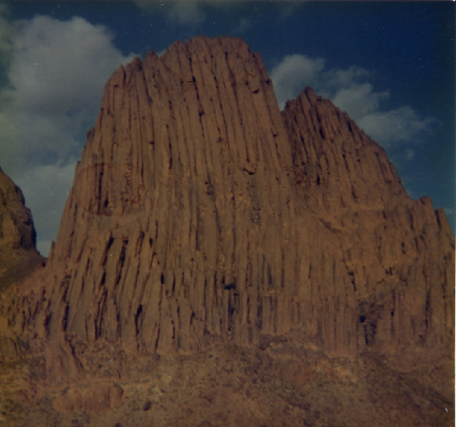
In the east-center the Tassili n'Ajjer mountains are honored by UNESCO as a World Heritage Site, both for nature and for ancient petroglyphs.
This is within the part of north Africa in which speakers of Maghrebi Arabic
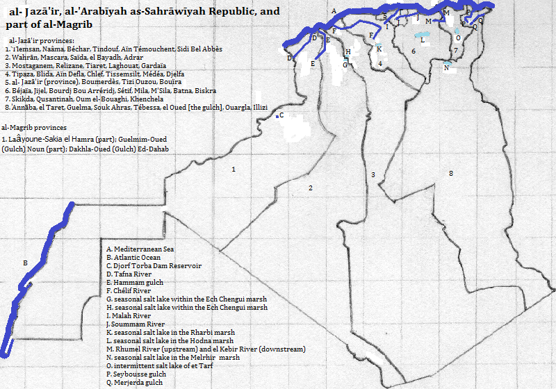
For a complete list of cities over a million, and selected others, see the table of Algerian cities. The important non-Algerian city is العيون (al-'uyūn or Laâyoune or Laayoune).
UNESCO honors three World Heritage Sites from the Islamic period: al Qal'a of Beni Hammad; the Kasbah of the city of الجزائر (al-Jazā'īr)--tourists enjoy the city generally
Tourists also enjoy Tamanrasset, Wahrān, the five cities of the M'Zab Valley, Tlemsan and El Oued (the Wadi or the Gulch) for their Islamic heritage, and Qusantinah for both its Islamic and pre-Islamic heritage.
The important gas field not located by a city is Hassi R'Mel in Laghouat Province.
Thousands of years ago, according to Christopher Ehret, speakers of the Boreafrasian dialects of Afroasiatic moved here when the climate was wetter, giving rise to the Berber languages. These remain the principal minority languages in Algeria.
The Punic people's colonized cities along the seashore as did the Greeks in Libya. Later the Roman conquerors introduced Latin and their conquerors introduced a Germanic language. All ethnic traces of these peoples has vanished. These people introduced new religions: the Punic people worshipped gods under generic names like Baal, El or Meloch; the Greeks worshipped gods like Zeus, Athena, Aphrodite and Poseidon; the Romans initially worshipped gods like Jupiter, Juno and Apollo, and later became Christians. North African Christian had great diversity in belief and so the Roman and Byzantine Empire treated them viciously as heretics, setting the stage for a big switch.
The Arabs conquered the region by the eighth century and changed the majority language and religion.
Turks ruled the coasts loosely in the early 19th century but have left no traces.
The French conquered the area by the early 20th century, but largely departed in the second half, leaving only handfuls of native French speakers, but the language persists in administration and international relations.
Jews settled here during the Roman Empire, then left for the most part when ישראל (Yisra'el)
UNESCO honors two World Heritage Sites from the pre-Islamic period (other than the one already mentioned): Djémila and Tipaza.
Tourists also like Annaba and Sétif for their pre-Islamic culture.
Ahaggar (Hoggar) Mountains, al-Jazā'īr (Algérie or Algeria)
north of Algeria
east, from the north of Algeria
east, from the south of Algeria
southeast and southwest of Algeria
southwest of the Chech Erg and of the Tanezrouft
south of westernmost Algeria
west of the Western Sahara
north of Western Sahara and west of westernmost Algeria
west of northern Algeria
1. Algérie in French; Algeria in English.
2. al-Maghreb means the west. Maroc in French; Morocco in English.
3. Wad or Wadi ranslates from Arabic as river or gulch.
4. Translates from Arabic as wilderness.
5. Tunisie in French; Tunisia in English.
6. The top ten were picked from https://www.thecrazytourist.com/15-best-places-to-visit-in-algeria/, accessed February, 2017.
7. Some would consider this several languages, others would subsume it under Arabic.
8. Israel in English.