| To Duval Family Home Page | Anglo-North America |
| To Chris Home Page | Canada |
| To Earth (Geography Home Page) | United States of America |
| North America | Alaska |
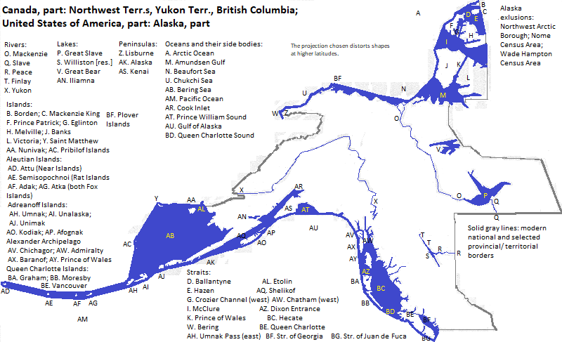
In the farthest northwest bordering the Arctic Ocean is the North Slope Plain, bounded southward by the Brooks Range of the Rocky Mountains which is partly in this area. Farther south are lowlands of the central Yukon River, North America's third longest. The Kuskokwin Mountains are flanked southward by a river with almost the same name, followed by the Alaska Range, which is topped by Mount McKinley,
Returning to the Arctic, great flatlands stretch for thousands of miles southeastward starting at the Beaufort Sea and continuing across the United States border.
To their north this area includes Banks and parts of Victoria and Melville Islands.
The plains's eastern edge is marked by some of the continent's largest lakes:
UNESCO honors four local areas as natural World Heritage Sites: Kluane/Wrangell-Saint Elias/ Glacier Bay/ Tatshenshini-Alsek; Nahanni National Park; the Canadian Rocky Mountain Parks (partly outside the area); and Wood Buffalo National Park (partly outside the area). Nahanni National Park
These parts of Alaska and Canada are in the part of North America in which English-speakers and Christians are the majority.
The largest city in western Canada is Vancouver. Whitehorse (population 25 thousand in 2016
Important oil and gas fields include: Greater Sierra gas field in northeastern British Columbia; Prudhoe Bay oil and gas fields; Kuparuk River oil field and Umiat Gas Gield--all three in Alaska's North Slope; and Kenai Gas Field on Alaska's Kenai Peninsula.
The Eskimo-Aleuts just before European contact lived around the edges of Alaska and the Beaufort Sea Coast. Many still live in these areas. They also lived beyond the area covered here--see the rest of Alaska, Nunavut and Greenland for descriptions of the Yupik and Inuit. Aleut is and was spoken in Alaska's southwest peninsula and islands.
The Na-Dene languages include the Athapascan group, Tlingit, Eyak and perhaps Haida. The Athapascan group was spoken, among other places, in much of inland northwestern Canada and Alaska. Tlingit, Eyak and Haida were spoken in southeastern Alaska and the Queen Charlotte Islands. UNESCO honors the Haida culture with its SGang Gwaay World Heritage Site. There are still about 200 speakers of Tlingit.
The Athapascan languages have more speakers--though still relatively few. Carrier is spoken by almost 4000; and Slave--pronounced like Slavey--by about 2000, some south of this area.
Wakashan languages were spoken in parts of British Columbia
Salishan languages were spoken in British Columbia and to its south. Secret societies were part of the local former religion. In the late 18th century smallpox, and in the early 19th century, influenze, reduced indiginous populutions in this area.
Kutenai was spoken in souteastern British Columbia. Some consider it an isolate; others an Uto-Aztecan language.
The Penutian languages--in the narrower sense--were represented in British Columbia by Tsimshian. Smallpox and measles in the early 19th century killed many. There are few or no current speakers.
The English arrived later, moving west across Canada. In the 19th century the Russians settled southeast Alaska and further south, but the government lost interest in its colonists and sold Alaska to the United States.
northwest of the Canadian Archipelago, north of mainland Northwest Territories and north of the North Slope east of Point Barrow
east of the Northwest Territories
east of Alberta and south of the Northwest Territories
south from southeastern British Columbia
south from southwestern British Columbia
west of British Columbia and south of Alaska
north of the Aleutian Islands and the Alaska Peninsula and west of Dillingham and Bethel Census Areas
south of the western Brooks Range, west of the center of Alaska and northwest of the western end of the Alaska Range
northwest of Alaska
1. Also called Mount Denali
2. North American rankings: Victoria, 4 (tenth in world); Banks, 8; and Melville, 10.
3. North American rankings: Great Bear, 4 (ninth in world); Great Slave, 5 (tenth in world)
4. The MacKenzie is the continent's second longest.
5. One of the first two (excluding 'Northern Lights') from https://us-keepexploring.canada.travel/things-to-do/top-10-attractions-northwest-territories, accessed February 6, 2019.
6. One of the first three from https://www.touropia.com/best-places-to-visit-in-british-columbia/, accessed February 6, 2019.
7. The first three from https://www.touropia.com/best-places-to-visit-in-alaska/, accessed February 6, 2019.
8. Side bar of https://en.wikipedia.org/wiki/Whitehorse,_Yukon, accessed February 6, 2019
9. First two from https://us-keepexploring.canada.travel/things-to-do/top-10-attractions-yukon, accessed February 6, 2019.
10. https://en.wikipedia.org/wiki/List_of_the_100_largest_municipalities_in_Canada_by_population, accessed February 6, 2019.
11. Greater than two million passengers in 2018 according to https://en.wikipedia.org/wiki/List_of_the_busiest_airports_in_Canada, accessed February 6, 2019
12. https://en.wikipedia.org/wiki/List_of_cities_in_Alaska, accessed February 6, 2019.
13. Greater than two million passengers according to the 2017 medium hub table in https://en.wikipedia.org/wiki/List_of_the_busiest_airports_in_the_United_States, accessed February 2, 2019
14. https://en.wikipedia.org/wiki/List_of_oil_fields and https://en.wikipedia.org/wiki/List_of_natural_gas_fields, both accessed February, 2019.
\
15. The Times Atlas of the Oceans (Van Nostrand Reinhold Company, 1983), "commodity loading ports" map.