| To Duval Family Home Page | Anglo-North America |
| To Chris Home Page | Canada |
| To Earth (Geography Home Page) | Western Canada and Anglo-Alaska |
| North America |
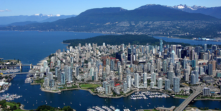
Vancouver, a city with 2.337 million metropolitan residents
The tallest building is Living Shangri-La, a mixed hotel-residential tower (2008, 659 feet). The previous tallest building, One Wall Centre, also mixed hotel-residential (517 feet, 2001), dampens wind effects through two tuned liquid column dampers, the first such in the world. Harbour Centre (581 feet to the top of the spire, 1977) is topped by a space-needle-like top whose observation deck was opened by Neil Armstrong, the astronaut, who left a commemorative foot print. The tallest building from 1939 to 1972 was the Fairmont Hotel Vancouver (1939, 369 feet), which features carved griffons, flying horses and gargoyles. Before that the highest was the Marine Building, with sea-life themed decorations on both its exterior and interior. Other buildings of note are: BC Place (1983), a multi-use stadium that has a roof that lets in 20% of the natural light; Science World (1986), which has a geodesic dome nicknamed the 'Golf Ball'; the H.R. MacMillan Space Centre (1968), whose roof was inspired by the shape of hats worn by pre-Columbian coastal locals; the Sylvia Hotel (1912), whose exterior is covered with Virginia Creeper ivy; and the East Building of the Vancouver Convention Centre with its five 'sails'.
Its waterside setting with coastal mountains in view make it a tourist attraction,
1. 2012 calculation from world-gazetteer.com, accessed February 6, 2013.
2. 2016 figure from https://en.wikipedia.org/wiki/List_of_the_100_largest_municipalities_in_Canada_by_population, accessed February 6, 2019.
3. Information about buildings is from emporis.com, accessed February 26, 2019.
4. One of the first three from https://www.touropia.com/best-places-to-visit-in-british-columbia/, accessed February 6, 2019.
5. https://en.wikipedia.org/wiki/List_of_the_busiest_airports_in_Canada, accessed February 6, 2019.
6. The Times Atlas of the Oceans (Van Nostrand Reinhold Company, 1983), "commodity loading ports" map.