| To Duval Family Home Page | Asia | |
| To Chris Home Page | ||
| To Earth (Geography Home Page) |
الراق (al-'Īrāq or Iraq) and الكويت (al-Kuwayt or Kuwait)
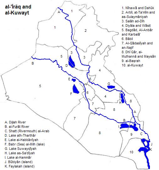
There are five geophysical zones, plus some transitional country. The eastern half of Kuwait
The heart of Iraq is the alluvial plains of the Tigris
Beyond this lake natural levies reduce the marshy chaos and salinization. This pattern continues upstream until the river is as much as ten meters below the lands beyond the levies, making irrigation difficult. The more downstream area was known as Sumeria and upstream as Akkadia. Together they were later known as Babylonia. There are three large marshy lakes downstream near the Tigris, two better defined ones southwest of the Euphrates, and one between the rivers. The Diyala River is the most important tributary of the Tigris in this zone.
Yet further upstream the land rises more rapidly, both towards' Iraq's edges and between the river. The uplands between are called the 'Island'
The remaining zone is the Zagros Mountains, and nearby ranges extending from southeastern Turkey. Here peaks reach close to 4,000 meters. The Diyali and the two Zabs cut into these mountains, and all three are dammed.
There are more than 28 million people here. A little over two thirds of them speak dialects of Mesopotamian Spoken Arabic.
More than 19 of every 20 people are Moslems. The majority, perhaps more than six in ten, are Shi'ites. Most of the rest are Sunni.
There are five cities with a million or more metropolitan residents, one in the northeast, one in the north, Baghdad in the center, one in southeastern Iraq and one in Kuwait. الموصل (al-Mawsil), also called Mosul, in the Shi'ite north, has two million residents. It is on the right bank of the Tigris, in the Assyrian Highlands. On the left bank are the ruins of Ninua (Nineveh), former imperial capital of Assyria.
Irbil is in the northeast, amongst the headwaters of the Great Zab, and at the edge of the Zagros Mountains.
Basra
The capital of Kuwait, Kuwait City
Table of Iraqi and Kuwaiti Cities. All three world heritage sites (Ashur (Qal'at Sherqat), Hatra and Samara Archaeological City) are on the city list.
There are large oil fields in Iraq (Rumaila, Kirkuk, Majnoon, West Qurna, East Baghdad, Halfaya, az Zubayr and Hahr Umr) and Kuwait (Burgan, Minagish, Raudhatain and Sabriya),
There are large container ports at al-Basrah (Iraq) and Shuwaykh (Kuwait City metropolitan area, Kuwait). Oil ports are at Mina al Bakr and Khor al Amaya (Iraq) and Mina' al-Ahmadi (Kuwait).
The world's earliest worked metal object
The first rowboat may have come from this area, judging from a clay model of one found in a grave in Eridu and dating from before 4000 BCE. The earliest evidence of canals comes from this area and from Syria (4000 BCE). One of the two earliest spots on Earth where irrigation is evidenced is the Sumerian region (6000 BCE). In pre-historic Neolithic times, religious objects were earth-mother statues and animal figurines, especially bulls. The earliest literate people were the Sumerians, whose language is unrelated to any of today's. Their religion includes the tale of the earth goddess, Inanna, descending into her sister's underworld realm where she is stripped of her clothes and hung on a nail for a time. Meanwhile agriculture withers.
From the Syrian desert the Semitic Akkadians conquered Sumeria and what became Akkadia. Their religion incorporated Sumerian elements. Thus Ishtarte (=Inanna) descended into the underworld to rescue her lover Tammuz (=Sumeria's Damuzi). There are still vestigial elements of this story in at least one modern religion. Later, other Semites, coming from the Assyrian Highlands which were named after them, ruled all of Mesopotamia. They spoke Aramaic, which became the imperial lingua franca, and is still spoken by Iraq's small Christian minority. Indo-Europeans, starting with Medes, invaded next, introducing the Zoroastrian religion. Even where it didn't convert fully, it influenced local religions, and those of transported peoples like the Jews. When the Roman Empire conquered adjacent territories, and later made Christianity the state religion, the majority in this area converted. The imperial persecutions to eliminate non-Greek versions of the religion did not reach here, and so Nestorian Christians persist today--albeit in small numbers. In the seventh century Arab Moslems conquered Iraq. Almost immediately the religion schismed over the sucession to its founding prophet, and the related assassination of Ali by the Abbasids. This division evolved into today's Sunni/ Shi'ite split. 1. Also transliterated from Arabic as al-Kuwayt.Around the area
north
east of northeastern Iraq
east of southeastern Iraq
southeast
south of Kuwait
south of Iraq
west of western Iraq
northwest
Other broad topics
Footnotes
2 Dijlah in transliterated Arabic.
3. al Furat in transliterated Arabic. Nahr is transliterated Arabic for 'river'.
4. 'Rivermouth' in transliterated Arabic is 'shatt'.
5. Hawr (transliterated Arabic) means 'lake'.
6. Al Jezireh in transliterated Arabic. It can also be translated as oasis.
7. I'm including the two dialects of Mesopotamian Spoken Arabic. Others may treat these as two languages. Still others would group all froms of Arabic as one language, despite their not being mutually intelligible, due to their shared norm of Standard Arabic.
8. al-Basrah in transliterated Arabic. Also called Bassorah or Busrah.
9. Formerly Qurein.
10. en.wikipedia.org/wiki/List_of_oil_fields, accessed 1/18/2010. I omitted the Mesopotamian Foredeep Basin because it seemed to vague a descriptor.
11. en.wikipedia.org/wiki/List_of_natural_gas_fields, accessed 1/18/2010.
12. List of "World Bulk Commodity Ports" in Alastair Cooper, ed., The Times Atlas of the Oceans (Times Books Ltd., 1983)
13. Jack Calloner, gen. ed., 1001 Inventions That Changed the World (Quintessence, 2009).