To Duval Family Home Page North America
To Chris Home PageUnited States of America
To Earth (Geography Home Page)Anglo-North America

Illinois (United States)

How is the land laid out?

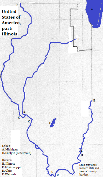
All of the state is within the Interior Plains; all but the southernmost tip is within the Central Lowland. The last bit is partly in the Interior Low Plateaus, partly in the Springfield-Salem Plateaus (a section of the Ozark Plateaus), and partly in the Mississippi Alluvial Plain (part of the Atlantic Coastal Plain). The state's western boundary is the Mississippi River and to its northeast is Lake Michigan. Tourists like Starved Rock State Park, Shawnee National Forest and Tunnel Hill State Trail.1

Map

map of the state of Illinois in the United States of America: showing selected county borders and some rivers, one lake and one reservoir

Who lives there?

This state is in the part of North America in which English-speakers and Christians are the majority.

The largest city is Chicago.

Springfield is a city of 116 thousand1 and a metropolitan population of 212 thousand2 centered south of the Sagamon River.3 It is the capital of the state and is a tourist attraction.4

Champaign-Urbana is a metropolitan area of 232 thousand2 centered on the cities of Champaign (population 81 thousand)1 and Urbana (population 41 thousand).1 Champaign is on a watershed boundary between the Embarras, Vermillion and Kaskaskia rivers5 in the northeastern part of the state. Urbana is adjacent. They are a tourist attraction and the main campus of the University of Illinois is located there.4

Rockford, population 153 thousand1 in a metropolitan area of 346 thousand,2 is located in northwestern Illinois along the Rock River.6 Its Anderson Japanese Gardens are a tourist attraction.4

There are also suburbs of Saint Louis on the Illinois side of the Mississippi River. Tourists also enjoy Galena, a smaller place.1

Who was there before?

Just before European contact everyone in the area spoken Algonquian languages such as Illinois. Before them was the Mississippian Culture, centered at Cahokia, just across the river from Saint Louis. The mounds there are a UNESCO World Heritage Site.

The French were the first Europeans in the area, traveling by waterways. The English-speakers claimed the area after the United Kingdom defeated France, and subsequently violently displaced the indiginous inhabitants.

Around the Area

north
east of the northeast corner of the state, across Lake Michigan
east
southeast
southwest

Footnotes

1. https://en.wikipedia.org/wiki/List_of_municipalities_in_Illinois, accessed January 23, 2018.
2. 2011 figure from https://en.wikipedia.org/wiki/Illinois_statistical_areas, accessed January 23, 2018.
3. The Sagamon flows into the Illinois River, which flows into the Mississippi River, which flows to the Gulf of Mexico/ México.
4. http://www.touropia.com/best-places-to-visit-in-illinois/, accessed January 23, 2018.
5. The Embarras and Vermillion flow into the Wabash, which flows into the Ohio, which flows into the Mississippi, which flows to the Gulf of Mexico/ México. The Kaskaski flows directly into the Mississippi.
6. The Rock River flows into the Mississippi, which flows to the Gulf of Mexico/ México.