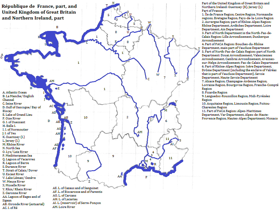
| To Duval Family Home Page | Europe |
| To Chris Home Page | France and its possessions |
| To Earth (Geography Home Page) | United Kingdom of Great Britain and Northern Ireland and its possessions |
Crudely France is hexagonal. Side one, in the northeast, is the land between the North Sea and the Rhin
UNESCO honors part of the Pyrénées, Mount Perdu, as a World Heritage Site.
Tourist attractions outside cities include Chamonix-Mont-Blanc and the Gorge du Verdon.
More than nineteen out of twenty speak French as their first language; almost everyone else can speak it. Similarly about nine in ten are formally Roman Catholic Christians, with the majority of the remainder being non-religious but with Catholic ancesters. The only metropolitan area with over ten million residents is Paris. See a list of French cities.
UNESCO World Heritage Sites for culture, predominantly post-RomanTourist attractions outside cities include Saint-Tropez.
There is an important natural gas field near Lacq.
The philosopher and mathemetician, René Descartes, was born in France; he did his important work in Holland. Other mathemeticians are mentioned under the cities where they were born or flourished.
Humans arrived here not too long after leaving Africa and co-existed with Neanderthals until the end of the Ice Ages. Probably the oldest linguistic group still around comprises the Basques,
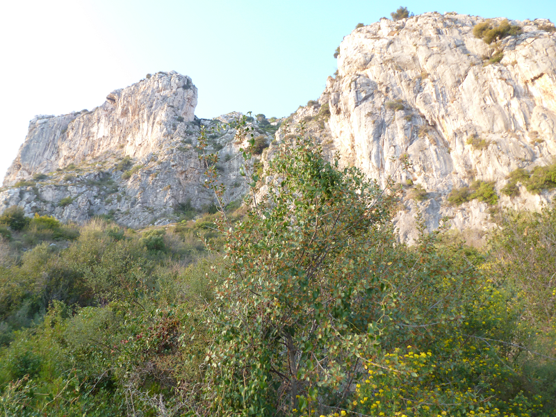
Cliffs within commune of Èze, France
north
northeast
east
east, from the southeast
southeast
southwest
west
northwest
northwest from Pas de Calais department
1. Rhein in German and Rhine in English.
2. Alpen in German, Alpi in Italian and Alps in English.
3. Translates as White Mountain in English.
4. Usually called the Basin of Acquitaine by the French.
5. The Bay of Biscay in English. Biscay refers to the Basques.
6. Armorican in English.
7. English Channel in English. The Manche means the Channel in French.
8. Straits of Dover in English.
9. http://www.touropia.com/tourist-attractions-in-france/, accessed 2/9/2015.
10. Within France the noted belfries are: those of the city halls in Armentières, Bailleul, Bergues, Comines, Douai, Dunkerque, Lille, Loos, Aire-sur-la-Lys, Arras, Boulogne-sur-Mer, Calais, Hesdin and Abbeville; that of St. Martin's Church in Cambrai; that of St. Eligius Church in Dunkerque; that of the former Municipal Hall (at present the tourist information center) in Doullens; that of the remaining city gate in Lucheux; and those in Gravelines, Béthune, Amiens, Rue and Saint-Riquier.
11. Among the places the canal goes through are the cities of Toulouse, Carcasonne, Narbonne, Béziers and Agde.
12. These are: the citadels at Arras, Besançon (and Fort Griffon), Blaye (and forts there or nearby), Mont-Louis and Saint-Martin-de-Ré; the city walls at Besançon, Briançon (and other features), Mont-Louis, Saint-Martin-de-Ré and Ville franche-de-Conflent (and other features there); the Tour dorée at Camaret-sur-Mer; the Ville neuve at Longwy; the Place forte at Mont-Dauphin; the Ville neuve to Breisach (and Breisach itself in Deutschland); and the watchtowers on Saint-Vaast-la-Houge and Tatihou.
13. The valley includes the cities of Angers, Saumur, Tours, Joué-lès-Tours, Blois and Orléans.
14. This consists of present or former cathedrals in Périgueux, Bazas, Bordeaux, Agen, Bayonne, Le Puy-en-Velay (and the Hôtel-Dieu Saint-Jacques there), Bourges (also a separate World Heritage Site), Saint-Lizier (plus other features there), Saint-Bertrand-de-Comminges, Auch, Cahors and Amiens (also a separate World Heritage Site); churches or collegial or parochial churches in Saint-Avit-Sénieur, La Suave-Majeure, Soudac-sur-Mer, Aire dur-l'Adour, L'Hôpital-Saint-Blaise, Oloron-Sainte-Marie, Clermont-Ferrand, La Charité-sur-Loire, Asquins, Neuvy-Saint-Sepulchre, Châlons-en-Champagne, Paris, Saint-Léonard-de-Noblat, Audressein, Valcabrèe, La Romieu, Rocamadour, Gavarnie, Jézeau, Orudis-Cotdoussan, Rabastens, Folleville, Compiègne, Saintes, Melle and Aulnay; basilicas in Bourdeaux, L'Épine, Comminges (and a chapel there), Toulouse (also the Hôtel-Dieu Saint Jacques there) and Poitiers; present or former abbeys or abbatial churches in Le Buisson-de-Cadouin, La Sauve-Majeure, Sorde-l'Abbaye, Saint-Sever, Vézelaly, Saint-Guihem-le-Désert, Saint-Giles-du-Gard, Conques, Moissac and Sant-Jean-d'Angély; a gate in Saint-Jean-Pied-de-Port; Mont-Saint-Michel (also a separate World Heritage Site); bridges between Aniane and Jean-de-Fos, and between Beaumont-sur-l'Osse and Larressingle, and at Estaing, Saint-Chély-d'Aubrac and Cahors; a dolmen at Gréalou; hospitals or hospices at Figeac, Aragnouet (also a chapel there) and Pons; a bell tower in Mimizan; and the routes between Nasbinals and Saint Chély-d-Aubrac, between Saint-Côme-d'Olt, between Montredon and Figeac, between Faycelles and Cajarc, between Bach and Cahors, between Lectoure and Condom, and between Aroue and Ostobat.
15. There are over a hundred spots many of which are within the Douai-Lens-Béthune-Valenciennes metropolitan area. Some are in cities such as Broay-la-Buissieè (also known as Broay-en-Artois), Béthune, Liévin, Loos (in the Lille-Kortrijk metropolitan area), Lens, Henin-Beaumont, Douai and Valenciennes.
16. https://en.wikipedia.org/wiki/List_of_natural_gas_fields, accessed in February, 2015.
17. Eukara in Basque.
18. The god's name is preserved in Lyon's old name, Lugdunum.
19. The locations are: Le Grand Lac de Clairvaux at Clairvaux-les-Lacs; Lac de Chalain, rive occidentale, at Marigny, Doucier and Fontenu; Lac d'Aiguebelette, zone sud, at Aiguebelette-le-Lac and Saint-Alban-de-Montbel; the Baie de Grésine at Brison-Saint-Innocent; the Baie de Châtillon at Chindrieux; Hautecombe at Saint-Pierre-de-Curtille; the Littoral de Tresserve; the Littoral de Chens-sur-Léman; Les Marais de Saint-Jorioz; Le Crêt de Chatillon at Sévrier; and the Secteur des Mongets at Sévrier and Saint-Jorioz.