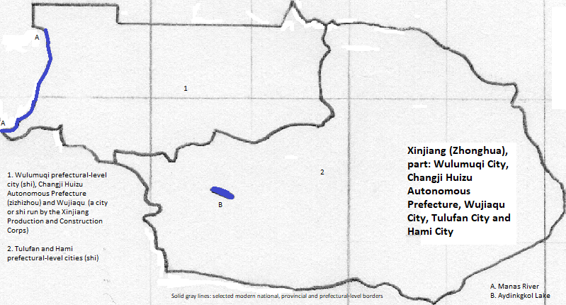
The east of the 新疆 维吾尔 自治区 (Xīnjiāng
Eastern 新疆 (Xīnjiāng) Province includes the eastern end of the Tian
Putonghua Spoken Chinese and an eclectic mix of Buddhism, Confucianism, Taoism and folk religions--for those who are observant--characterize the majority here as in other parts of eastern and central 中华 (Zhōnghuá).
乌鲁木齐 (Wūlǔmùqí) is the capital of 新疆 (Xīnjiāng).
Tocharians, an Indo-European people, lived there and may have been the people of the Jushi Kingdom (whose capital was later named Jiaohe). The kingdom was near Aydingkul lake in the Turpan Basin but they also lived on the north slopes of the Tian Mountains. Gaochang was among their cities. The Chinese and the Xiongnu split the kingdom in 60 BCE when settling the war between the empires. (The ethnicity of the Xiongnu is unclear.) Han Chinese migrated into the basin as did Sogdians, an Iranian group who practiced Mazdaism. For a while a Turkic confederation, the Tiele, ruled (circa 500 CE). A kaghanate comprised of a linguistically isolated group, the Ruan-ruan, conquered them only to be in turn conquered by another Turkic confederation (mid-sixth century). The Chinese conquered the basin again in the seventh century though the Tibetans conquered it in the late eighth century, holding it only briefly. The Uyghurs seized it next (803) and the group fled to the basin when the core of their khannate was captured by the Kirghiz. The Uyghurs were initially Manichean but converted to Buddhism, and built the shrines at the Bezeklik Caves. Their Turpan Basin state became a vassal to the Khitans, and then to the Mongols. They established the city of Qocho (later Halahezhou) at the site of Gaochang. In the second half of the 15th century the subject Uyghurs converted to Islam.
| Name | Year | Population |
哈拉和卓 (Hālāhézhuō)| 1300 CE | 40,000 | |
哈拉和卓 (Hālāhézhuō)| 1500 CE | 60,000 | |
| 吐鲁番 (Tǔlǔfān) Shì | 2010 CE | 623,000 |
Hāmì also experienced changes: early on going back and forth between the Xiongnu and the Chinese, later under the Turks and the Mongols (ruling as the Yuan Dynasty). Later on it was fought over by tribes of Mongols, Turks and the Chinese.
The 乌鲁木齐 (Wūlǔmùqí) area was ruled by the Chinese in the seventh century, then by Uyghurs. It may have been depopulated when the Mongols settled there and named the collection of their towns Bishbalik.
The entirety of the area came under Chinese directly or indirect rule during the Qing Dynasty and large scale migration of Han Chinese ensued.
UNESCO honors the past of this (and other areas) with a World Heritage Site for 'Silk Roads of the Chang'an-Tianshan corridor.' Locally this includes the Qocho/ Gaochang ruins and the Jiaohe ruins in 吐鲁番 (Tǔlǔfān) Shì, and the Beshbalik (or Beiting) city ruins in Jimsar County of Chāngjí Huízú. Gaochang and Jiaohe are also tourist attractions.
west and north of Chāngjí Huízú
northeast of Chāngjí Huízú and north of western Hāmì Shì
northeast
southeast
south
1. Or Hsin-chiang. Sinkiang in English; it can translate as the New Frontier.
2. Uyghur or Uighur in English.
3. Or Tzu-chih-ch'u. Autonomous Region in English.
4. Or Chung-hua or Junghwa in transliterated Pŭtōnghuà Chinese. The first character means central and the second means Chinese/ illustrious/ flowery. China is its English name.
5. Or Ch'ang-chi-hui-tsu.
6. Or Tzu-chi-chou. Autonomous Prefecture in English.
7. Or Wu-lu-mu-ch'i or Ürümqi or Urumchi.
8. Or shih. City in English.
9. Or T'u-lu-fan. Turpan or Turfan in English.
10. Or Ha-mi.
11. Wǔjiāqú Shi is administered by the 新疆 (Xīnjiāng) Production and Construction Corps.
12. Or Tien; translates literally as Heavenly.
13. https://en.wikipedia.org/wiki/AAAAA_Tourist_Attractions_of_China, accessed July 7, 2018; also in Zhou Shunwu, China Provincial Geography (Foreign Languages Press, 1992).
14. table of subdivisions in https://en.wikipedia.org/wiki/Changji_Hui_Autonomous_Prefecture, accessed July 7, 2018.
15. Zhou Shunwu, China Provincial Geography (Foreign Languages Press, 1992).
16. The ethnically Uyghur city was conquered 1257 by the Tsadgadaina Khaanat Ulus (Chagatai Khannate) so it may or may not have retained the Chinese form of the Uyghur name.
17. Tertius Chandler, Four Thousand Years of Urban Growth, 2nd ed. (The Edwin Mellen Press, 1987), pg. 339 for 1300 and "Tables of the World's Largest Cities' for 1500. It was the largest city in this area in 1300 and 1500. It was probably the largest city in the area in 1400 since it was 'the second largest city in Kashgar's kingdom' (pg. 339).
18. https://en.wikipedia.org/wiki/Xinjiang, accessed July 6, 2018, citing "Guo wu yuan ren kou pu cha ban gong; council, Guo jia tong ji ju ren kou he jiu ye tong ji si bian = Tabulation on the 2010 population census of the people's republic of China by township / compiled by Population census office under the state; population, Department of; statistics, employment statistics national bureau of (2012). Zhongguo 2010 nian ren kou pu cha fen xiang, zhen, jie dao zi liao (Di 1 ban. ed.). Beijing Shi: Zhongguo tong ji chu ban she. ISBN 978-7-5037-6660-2." The metropolitan area might be deemed to be just the Gaochang District, which had a population of 273 thousand--see table of subdivisions in https://en.wikipedia.org/wiki/Turpan, accessed July 6, 2018.