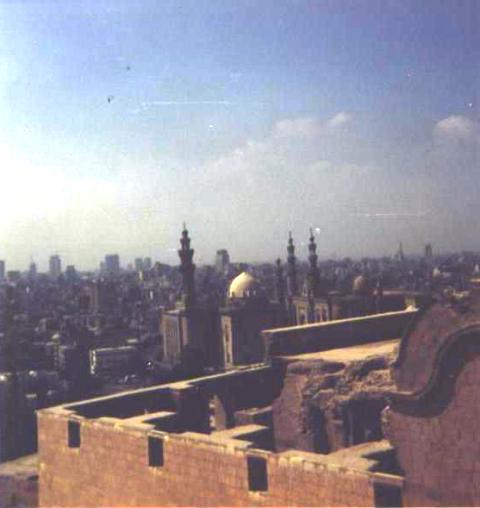
Cityscape with the Mosque of Sultan Hassan
| To Duval Family Home Page | Africa | |
| To Chris Home Page | Eastern Egypt | |
| To Earth (Geography Home Page) | Miṣr (Egypt) |
القاهرة (al-Qāhirah or Le Caire or Cairo)
The old Islamic city is honored as a World Heritage Site. The al-Qatta'i (al-Qatai) District features the Mosque of Ibn-Tulun and in the al-Azhar district are gates, towers and five mosques from the early days of the city, including the mosques of al-Hakim and of al-Azhar. The latter was an important center of Islamic studies. The citadel is somewhat later, from the 12th century CE. Nearby in the 'City of the Dead' are mausoleums from the Mameluke era as is the Mosque and Madrassa of Sultan Hassan. The most famous Ottoman era building is the Mosque of Muhammad Ali.
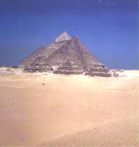
Al-Jizāh (Giza or Gizeh) is on the opposite (left) bank of the Nile. It is famous for the Great Pyramids and Sphynx dating from ancient Egypt's first kingdom. These are part of a World Heritage Site. The three pyramids are the "Horizon of Cheops [Khufu, Khnemkhufu]" or "Great" Pyramid, the "Great is Chepren [Chefren, Khafre, Khufukhaf]" Pyramid and the "Divine is Mycerinus [Menkaure]" Pyramid. An old solar boat was found at the base of the Great Pyramid.
Shubrā al-Khaymah (or Shubra-El-Khema) is in the northern part of the metropolitan area. Its industrialization dates from the 1820's.
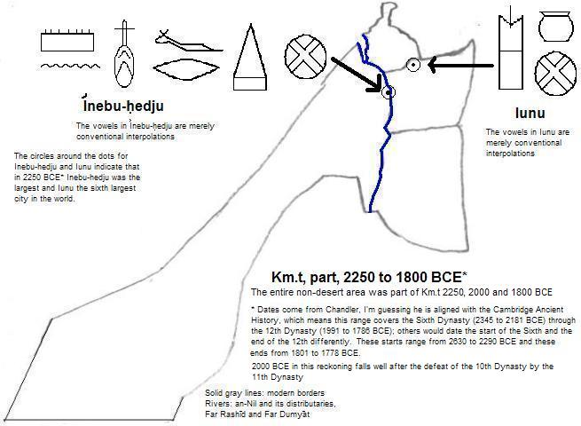
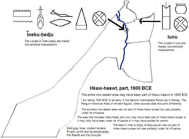
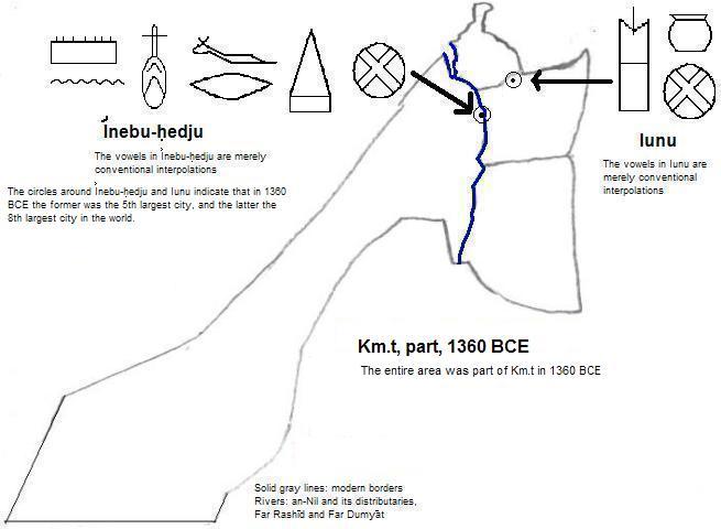
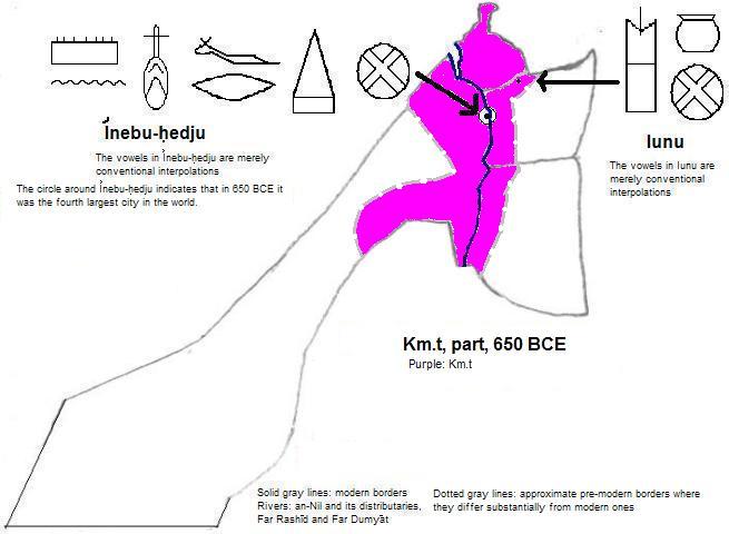
In the northeast part of the city is the site of ỉwnw (Iunu), later called Ηλιούπολις (Ēlioúpolis or Heliopolis).
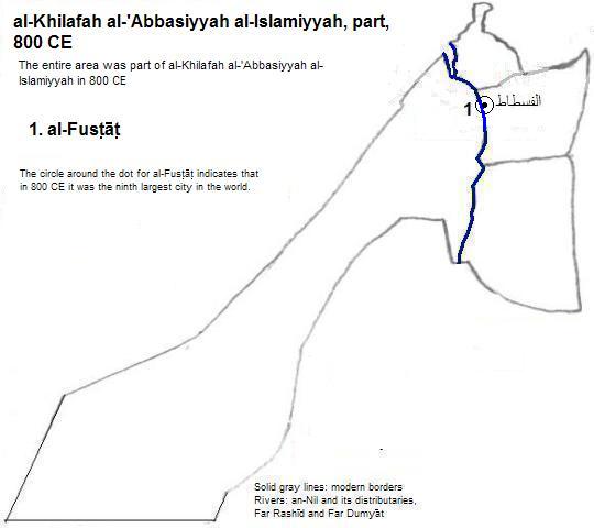
In the seventh century south of today's city center, الفسطاط (al-Fusṭāṭ) was founded, by the Arab conquerors. It was intentionally burned in the 12th century to prevent its wealth from being taken by Christian Crusaders and most of the remains became a garbage dump for القاهرة (al-Qāhirah). Al-Qatta'i was built adjacent to it and is sometimes conflated with it.
| Name | Year | Population | Political entity |
| ỉwnw | 2250 BCE | | Km.t (Kemet or Egypt) | |
| ỉwnw | 2000 BCE | | Km.t (Kemet or Egypt) | |
| ỉwnw | 1800 BCE | | Km.t (Kemet or Egypt) | |
| ỉwnw | 1360 BCE | 30,000| Km.t (Kemet or Egypt) | |
| الفسطاط (al-Fusṭāṭ) | 800 CE | 100,000| al-Khilafah al-'Abbasiyyah al-Islamiyyah (Abbasid Empire) | |
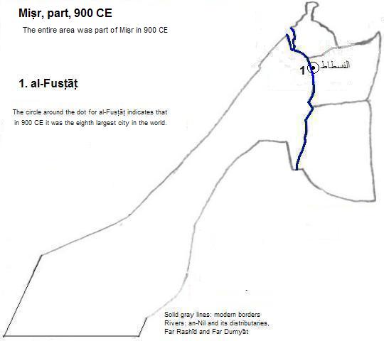
| الفسطاط (al-Fusṭāṭ) | 900 CE | 150,000| Miṣr (Tulunid Egypt) | |
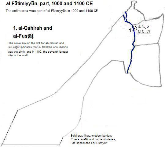
| القاهرة (al-Qāhirah) and الفسطاط (al-Fusṭāṭ) | 1000 CE | 135,000| al-Fāṭimiyyūn (Fatimid Empire) | |
| القاهرة (al-Qāhirah) and الفسطاط (al-Fusṭāṭ) | 1100 CE | 150,000| al-Fāṭimiyyūn (Fatimid Empire) | |
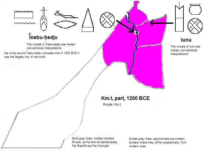
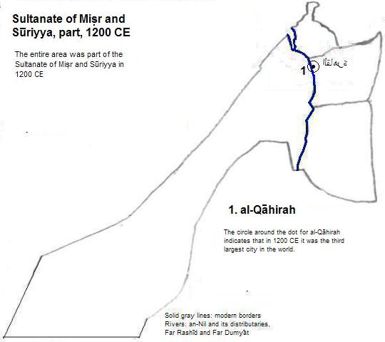
| القاهرة (al-Qāhirah) | 1200 CE | 200,000| Sultanate of Miṣr and Sūriyya (Ayyubid Empire) | |
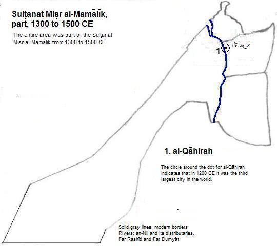
| القاهرة (al-Qāhirah) | 1300 CE | 400,000| Sulṭanat al-Māmalīk (Mamluk Empire) | |
| القاهرة (al-Qāhirah) | 1400 CE | 360,000| Sulṭanat al-Māmalīk (Mamluk Empire) | |
| القاهرة (al-Qāhirah) | 1500 CE | 400,000| Sulṭanat al-Māmalīk (Mamluk Empire) | |
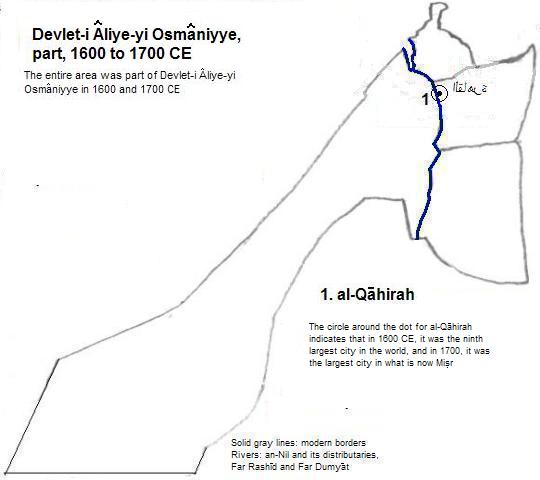
| القاهرة (al-Qāhirah) | 1600 CE | 200,000| Devlet-i Âliye-yi Osmâniyye (Ottoman Empire) | |
| القاهرة (al-Qāhirah) | 1700 CE | 175,000| Devlet-i Âliye-yi Osmâniyye (Ottoman Empire) | |
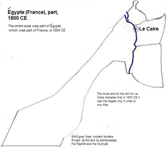
| Le Caire | 1800 CE | 186,000| Égypte (Egypt), which was part of France | |
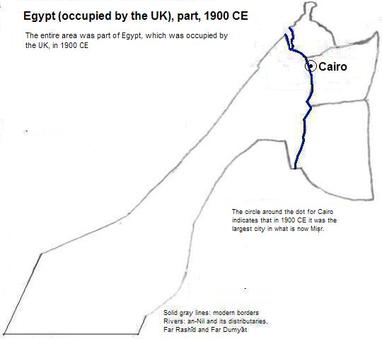
| Cairo | 1900 CE | 595,000| Egypt, which was occupied by the UK | |
Cityscape with the Mosque of Sultan Hassan
Step Pyramid at Saqqara

1. Mars (the planet) in literal translation; also said to translate as victory or victorious.
2. The modern district that in English is called Heliopolis is south of the site. The site of ỉwnw is in the district of al-Maṭarīyah.
3. The maps and tables of populations in this article for 900 label الفسطاط (al-Fusṭāṭ and ignore al-Qatta'i.
4. I'm guessing that Chandler is using the Cambridge Ancient History's dating, in which case 2250 falls within the Sixth Dynasty (2345 to 2181 BCE). Others date that dynasty's start from 2630 BCE (Bernal) to 2290 BCE (Helck). See Chronological Chart I in Martin Bernal, Black Athena, Volume II (Rutgers University Press, 1991). 2000 BCE then falls within the 11th Dynasty (2133 to 1981 BCE), whose start others date from 2287 (Mellaart) to 2134 (Helck). By this reckoning 2000 BCE was well after the defeat of the 10th Dynasty by the 11th. And 1800 BCE falls within the 12th Dynasty (1991 to 1786), whose start others date from 2155 (Mellaart) to 1979 (Bernal).
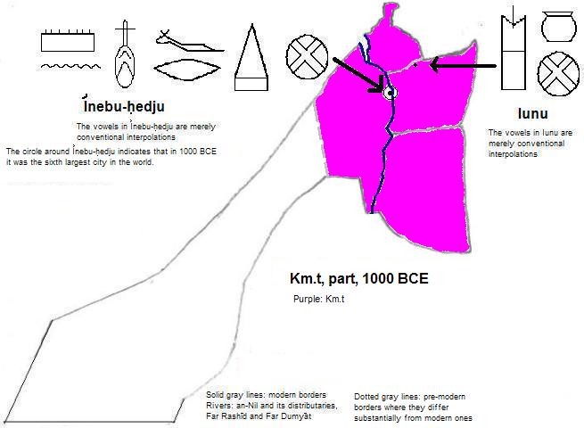
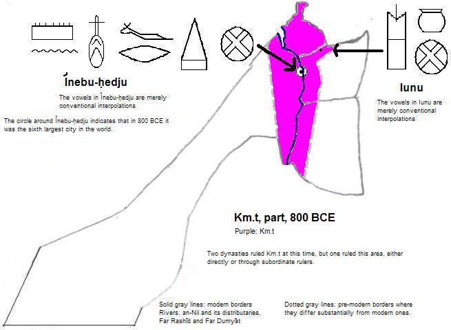
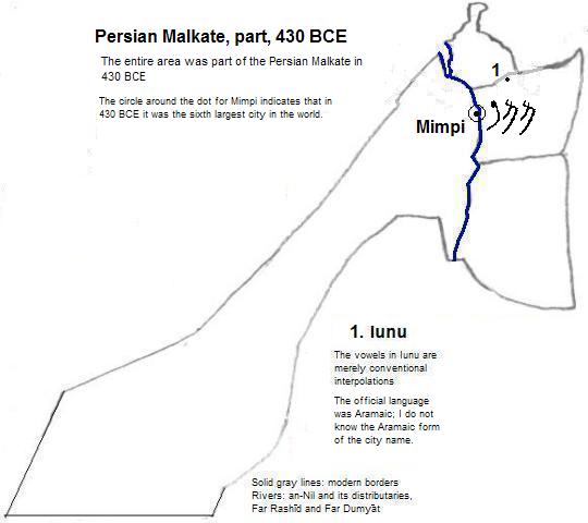
5. In 2250 BCE ỉwnw was smaller than Erech, which was smaller yet than Nippur; Nippur had an estimated population of 30,000 according to Tertius Chandler, Four Thousand Years of Urban Growth, 2nd ed. (The Edwin Mellen Press, 1987), Tables of World's Largest Cities". In 2000 BCE ỉwnw was smaller than Assur, which was smaller than Nippur, which was smaller than Mari, which was smaller than Susa, which had an estimated population of 25,000. In 1800 BCE ỉwnw was bigger than Susa, which still had an estimated population of 25,000. القاهرة (al-Qāhirah) was the world's third largest city in 1200, 1300, 1400 and 1500 CE; as ỉwnw it was fifth rank in 1800 BCE; as ỉwnw in 2250 and 1360 BCE and as القاهرة (al-Qāhirah) in 1000 CE it was sixth rank, presumably including الفسطاط (al-Fusṭāṭ) in 1000; as القاهرة (al-Qāhirah) seventh in 1100 CE (presumably including الفسطاط (al-Fusṭāṭ)); as al-Qatta'i (Chandler says Fostat meaning الفسطاط or al-Fusṭāṭ) eighth in 900 CE; as ỉwnw in 2000 BCE and as الفسطاط (al-Fusṭāṭ) in 800 CE and as القاهرة (al-Qāhirah) in 1600 CE it ranked ninth.
6. Chandler, ibid., "Tables of World's Largest Cities"