The waterfront of 神戸 (Kōbe) is dominated by the red steel Port Tower. The tallest building as of early 2014 is the 54 story City Tower Kobe Sannomiya.
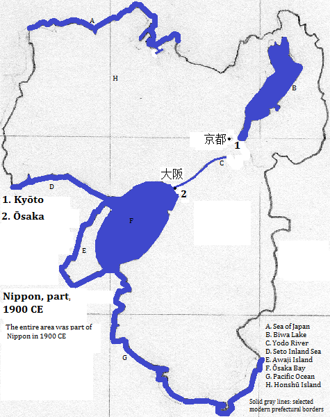
The area is long of importance.
Soon after it was abandoned 奈良 (Nara) became the capital. UNESCO honors as a World Heritage Site (WHS) several extent buildings: Tōdai-ji; Kōfuku-ji; the Katsuga Shrine and its sacred forest; Gangō-ji; Yakusha-ji; Tōshōdai-ji; and the site of the Nara Palace. Tōdai-ji is famed for its Kondō (Great Buddha Hall) and is popular with tourists;
Later 京都 (Kyōto)--in its early centuries as capital called 平安京 (Heian-kyō)--and then 大阪 (Ōsaka) became the area's pre-eminent city.
The WHS, 'Buddhist Monuments in the Hōryū-ji Area,' is located in 斑鳩 (Ikaruga), Nara Prefecture. They are among the oldest wooden buildings (seventh to eight centuries) and were built when Buddhism was new in ⽇夲 (Nippon). 斑鳩 (Ikaruga), located east southeast of 大阪 (Ōsaka), had a population in 2006 of 29 thousand.
Another WHS and popular tourist destination is Himeji-jo (castle) in 姫路 (Himeji) in Hyogo Prefecture. The complex includes 83 buildings, most famously Dai-Tenshu, whose white walls give the castle the nickname Shiragi-jo (Castle of the White Heron). The city, which is on the Ichi River west northwest of 神戸 (Kōbe), had a 2008 population of 536 thousand.
Part of the same WHS that honors the old buildings of 京都 (Kyōto) also honors those in two other cities: 大津 (Ōtsu) for Enryaku-ji; and 宇治 (Uji) for Byōo-in and Ujigami Shrine. 大津 (Ōtsu), a city of 329 thousand,
'Sacred Sites and Pilgrimage Routes in the Kii Mountain Range' is a WHS partly in this metropolitan area. Trails, passing through small towns, lead to and connect the three sacred sites of Yoshino, Omine and Kumano Sanzan.
Two of the nation's busiest airports
| Name | Year | Population | Political entity |
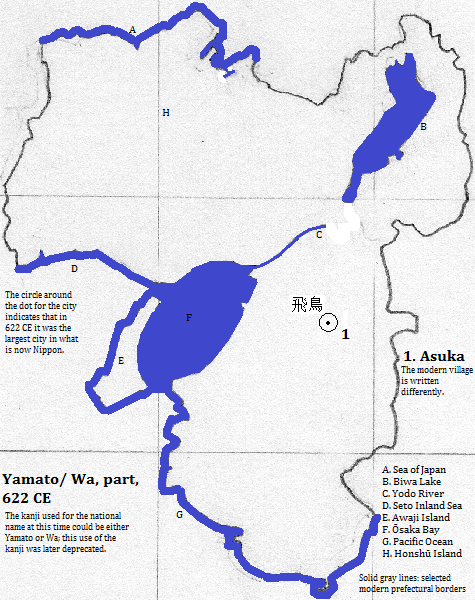
| 飛鳥 | 622 CE | | Yamato/ Wa | |
| 平安京 (Heian-kyō) | 800 CE | 200,000| ⽇夲 (Nippon) | |
| 平安京 (Heian-kyō) | 900 CE | 200,000| ⽇夲 (Nippon) | |
| 平安京 (Heian-kyō) | 1000 CE | 175,000| ⽇夲 (Nippon) | |
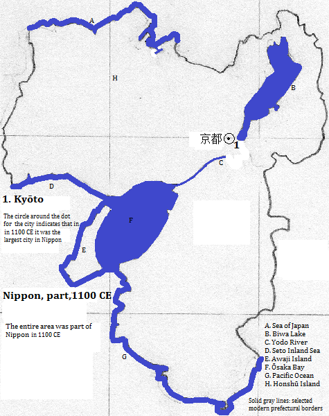
| 京都 (Kyōto) | 1100 CE | 175,000| ⽇夲 (Nippon) | |
| 京都 (Kyōto) | 1200 CE | 100,000| ⽇夲 (Nippon) | |
| 京都 (Kyōto) | 1300 CE | 40,000| ⽇夲 (Nippon) | |
| 京都 (Kyōto) | 1400 CE | 150,000| ⽇夲 (Nippon) | |
| 京都 (Kyōto) | 1500 CE | 40,000| ⽇夲 (Nippon) | |
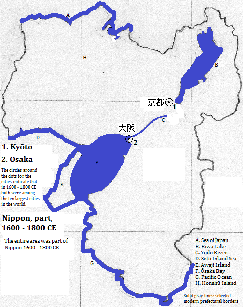
| 大阪 (Ōsaka) | 1600 CE | 360,000| ⽇夲 (Nippon) | |
| 京都 (Kyōto) | 1600 CE | 300,000| ⽇夲 (Nippon) | |
| 大阪 (Ōsaka) | 1700 CE | 380,000| ⽇夲 (Nippon) | |
| 京都 (Kyōto) | 1700 CE | 350,000| ⽇夲 (Nippon) | |
| 大阪 (Ōsaka) | 1800 CE | 383,000| ⽇夲 (Nippon) | |
| 京都 (Kyōto) | 1800 CE | 377,000| ⽇夲 (Nippon) | |
| 大阪 (Ōsaka) | 1900 CE | 970,000| ⽇夲 (Nippon) | |
| 京都 (Kyōto) | 1900 CE | 362,000| ⽇夲 (Nippon) | |
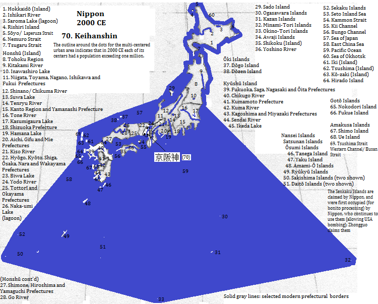
| 京阪神 (Keihanshin) | 2000 CE | 17,416,000| ⽇夲 (Nippon) | |
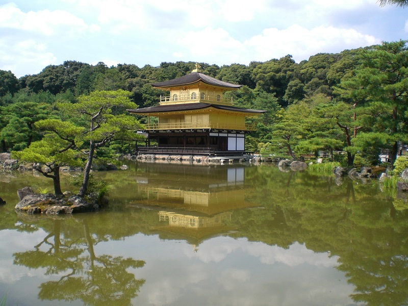
Kinkaku-ji (Golden Pavilion), 亰都 (Kyōto), ⽇夲 (Nippon)
Historical maps


Footnotes
1. The name uses a pronunciation of a character selected from each of the three main cities. The order is then 京都 , 大阪, 神戸 (Kyōto-Ōsaka-Kōbe). English representations of the composite are ordered differently: Ōsaka-Kōbe-Kyōto.
2. In less formal contexts the pronunciation shifts to the more modern: Nihon. In English: Japan.
3. 2012 calculation from world-gazetteer.com, accessed 2/6/2013.
4. Emporis.com, accessed 5/12/2014.
5. http://en.wikipedia.org/wiki/List_of_cities_in_Japan, accessed 3/25/2014.
6. The Times Atlas of the Oceans (Van Nostrand Reinhold Company, 1983), "commodity loading ports" map.
7. Tertius Chandler, Four Thousand Years of Urban Growth, 2nd ed. (The Edwin Mellen Press, 1987), "Tables of World's Largest Cities," lists 'Kashiwara' (more properly Kashihara, in Nara Prefecture) as the island chain's largest city in 100 CE with a population estimate between 50 and 51 thousand. I omitted it from the table as I'm unconvinced that it held that status at that time. The site is nonetheless of great religio-political importance as the place where myth says the first (legendary) emperor descended to earth. It was briefly a capital at the turn of the 7th century.
8. The modern village has a different kanji name.
9. http://www.touropia.com/tourist-attractions-in-japan/, accessed 3/26/2014.
10. UNESCO, World Heritage Sites (Firefly Books, 2010).
11. Side banner of http://en.wikipedia.org/wiki/Ikaruga,_Nara, accessed 3/26/2014.
12. Airports with more than 10 million passengers in 2010 determined from http://en.wikipedia.org/wiki/List_of_the_busiest_airports_in_Japan, accessed 3/26/2014.
13. Chandler, op. cit.. He puts 飛鳥 (Asuka) in 622 CE as smaller than Kyonju, which was smaller than Hangzhou, which had a population estimate of 60 thousand; it was larger than Bezwada, which had a population estimate of 50 thousand. 飛鳥 (Asuka) was the largest city in ⽇夲 (Nippon) in 622 CE. 平安京 (Heian-kyō) was the fifth largest city in the world in 800 and 1000 CE, and fourth in 900. As 京都 (Kyōto) it was the third largest in the world in 1100, eighth in 1400, fifth in 1600, ninth in 1700 and tenth in 1800 CE. From 800 to 1100 and in 1400 京都 (Kyōto) under its older or current name was the largest in ⽇夲 (Nippon). 大阪 (Ōsaka) was the fourth largest in the world in 1600, seventh in 1700 and ninth in 1800 CE. It was the largest in ⽇夲 (Nippon) in 1600 CE.
14. 倭 was used by all scribes, including Japanese ones, to represent the nation. It can be pronounced as Wa or Yamato. This way of representing the nation was deprecated later.
15. Chandler, op. cit., "Cities of Asia, 1500."