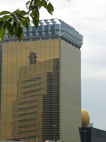
View of a skyscraper from the Sumida River, 東京 (Tōkyō), ⽇夲 (Nippon)
| To Duval Family Home Page | Asia |
| To Chris Home Page | ⽇夲(Nippon) |
| To Earth (Geography Home Page) |
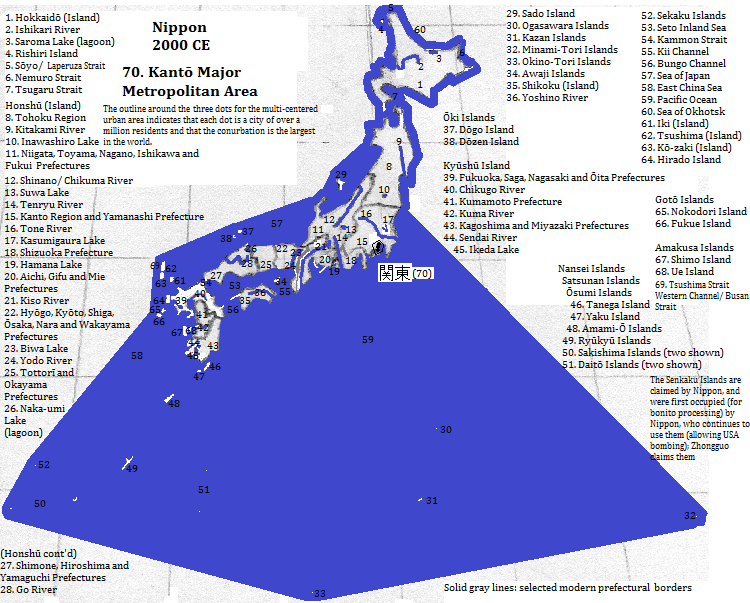
関東 (Kantō) Major Metropolitan Area, also called Greater 東京 (Tōkyō) in the Kantō Region of ⽇夲 (Nippon
東京 (Tōkyō) itself is at the head of Tōkyō Bay, within the Kantō Plain and along the Sumida, Ara, Edo (right bank) and Tama (left bank) rivers. The 'city' had a population of 8.6 million in 2007.
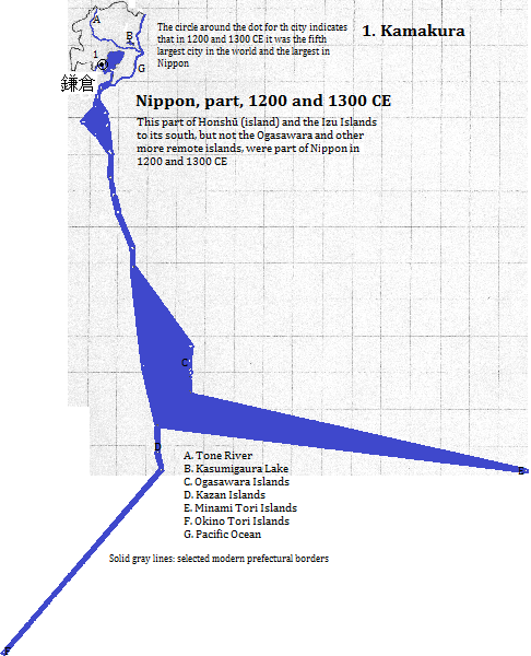
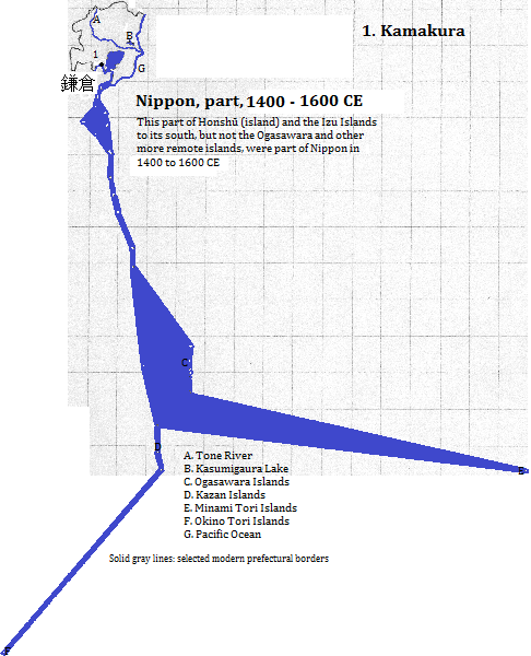
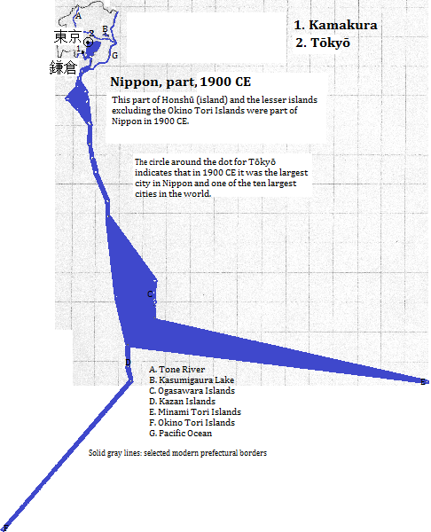
From the late 12th century until the 1333 CE 鎌倉 (Kamakura) became the de facto capital of ⽇夲 (Nippon). Thereafter it was regionally important until the 16th century, whereafter it declined to village sized. In the 20th century it revived to the become a moderate-sized city (174 thousand in 2008
横浜 (Yokohama) is located along the west central coast of Tōkyō Bay and had a population of 3.6 million in 2008.
巛崎 (Kawasaki) is located just south of 東京 (Tōkyō), beyond the right bank of the Tama River and on Tōkyō Bay. It had a population of 1.4 million in 2008.
さいたま
The nation's second busiest airport, Narita International, is located at 成田 (Narita) and the smaller Shibayama, both in Chiba Prefecture, east-northeast of 東京 (Tōkyō). 成田 (Narita) had a 2008 population of 125 thousand.
The Minami Kantō Gas Field is one of the world's largest
| Name | Year | Population |
| 鎌倉 (Kamakura) | 1200 CE | 175,000 |
| 鎌倉 (Kamakura) | 1300 CE | 200,000 |
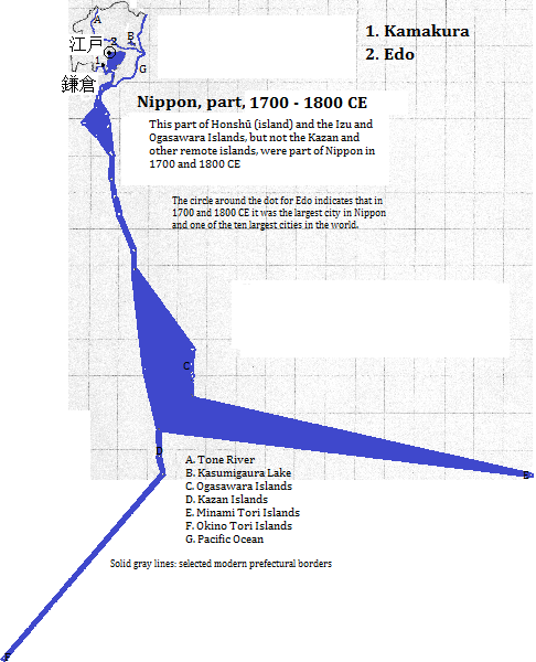
| 江戸 (Edo) | 1700 CE | 688,000 |
| 江戸 (Edo) | 1800 CE | 685,000 |
| 東京 (Tōkyō) | 1900 CE | 1,497,000 |
| 関東 (Kantō) Major Metropolitan Area | 2000 CE | 38,198,000 |
View of a skyscraper from the Sumida River, 東京 (Tōkyō), ⽇夲 (Nippon)
1. Informally also called Nihon in Japanese, and known as Japan in English.
2. 2012 calculation from world-gazetteer.com, accessed 2/6/2013. The exact definition of the metropolitan area used in this source may vary from that formally included in the 'major metropolitan area.'
3. http://en.wikipedia.org/wiki/Special_wards_of_Tokyo, accessed 3/25/2014. The city existed until 1943 after which it devolved into 23 wards. The 23 wards are less than the '東京 (Tōkyō) Metropolitan Government,' which comprises the entire 東京 (Tōkyō) prefecture. That in turn is much less than the Major Metropolitan Area, which is a statistical grouping.
4. http://www.touropia.com/tourist-attractions-in-japan/, accessed 3/26/2014.
5. Emporis.com, accessed 6/4/2014. The Toranomon Hills building was topped out but not yet open as of 6/4/2014. It, the Tōkyō and the Roppongi Hills Mori Tower are located in the Minato Ward. The Tōkyō City Hall is located in the Shinjuku Ward. The Imperial Palace is in the Chiyoda Ward.
6. Airports with more than 10 million passengers in 2010 determined from http://en.wikipedia.org/wiki/List_of_the_busiest_airports_in_Japan, accessed 3/26/2014.
7. The Times Atlas of the Oceans (Van Nostrand Reinhold Company, 1983), "commodity loading ports" map.
8. http://en.wikipedia.org/wiki/List_of_cities_in_Japan, accessed 6/4/2014.
9. Originally part of the Taiisan Kotokuin temple's main hall, which was destroyed in a 15th century tsunami (emporis.com, accessed 6/4/2014).
10. http://en.wikipedia.org/wiki/Kamakura,_Kanagawa, accessed 6/4/2014.
11. See the map for the 関東 (Tōkyō) Major Metropolitan Area included in the table in http://en.wikipedia.org/wiki/Greater_Tokyo_Area, accessed 3/25/2014.
12. emporis.com, accessed 6/4/2014.
13. http://en.wikipedia.org/wiki/Kamakura,_Kanagawa, accessed 6/4/2014.
14. The city is written in hiragana characters, unlike the prefecture with the same name, which is written in kanji. See, for example, http://en.wikipedia.org/wiki/Saitama,_Saitama and http://www.city.saitama.jp/index.html.
15. http://en.wikipedia.org/wiki/List_of_natural_gas_fields, accessed 6/4/2014.
16. See map at http://ja.wikipedia.org/wiki/%E5%8D%97%E9%96%A2%E6%9D%B1%E3%82%AC%E3%82%B9%E7%94%B0.
17. Tertius Chandler, Four Thousand Years of Urban Growth, 2nd ed. (The Edwin Mellen Press, 1987), "Tables of World's Largest Cities." This source shows 鎌倉 (Kamakura) as the largest city in ⽇夲 (Nippon) in 1200 and 1300 CE and 東京 (Tōkyō) as largest in 1700, 1800 and 1900. 東京 (Tōkyō) is the largest metropolitan area in the world today (2012 calculation from world-gazetteer.com, accessed 2/6/2013), and, per Chandler, was the seventh largest in 1900 CE. As 江戸 (Edo, sometimes spelled Yedo in English) Chandler has it as the world's second largest in 1800 and fourth largest in 1700.